535
Senior MemberSenior Member
535

PostNov 12, 2014#701

ward24 wrote: Its important to note the routes within the city, depicted above, have had substantial analysis done in a number of studies, and are probably unlikely to change much, with the exception of a few details downtown near the current Civic Center station / Amtrak, the routing from there to Washington Av, and perhaps the route north from downtown to Natural Bridge. The City alignment I would consider largely finalized. This is primarily a street running system very much like the just completed Green Line in Minneapolis / St. Paul.

It looks like there would be much higher station density along this line than the E-W line. Do you see the money being there for all those stations? Especially downtown. This current alignment would be amazing but do you see some stations getting axed?

9,565
Life MemberLife Member
9,565

PostNov 12, 2014#702

Saw that CMT is commissioning a study on other ways to fund trasnit. They could have saved money and read the AASTHO report on different ways to fund it and pros and cons with each option. Transit miles travelled fee looked liked a good option

3,547
Life MemberLife Member
3,547

PostNov 12, 2014#703

^ Yes, I read that and it made me think something is in the works. In fact, a few things make me think this may be linked to the Ferguson Commission.

1) CMT Looking to study alternative funding solutions for transit: http://cmt-stl.org/making-the-case-for- ... t-funding/

*Some ideas include a change to the state constitution that would allow areas like St. Louis to use are gasoline funds as we see fit.

2) The city and county applying to be one of the "promise zone" that would open up funding and give priority to areas that are "distressed".

http://stlouis.cbslocal.com/2014/11/12/ ... signation/

3) Stenger explicity mentioning the need to change county transportation policy and create "community centers" aka TOD around transit.

http://news.stlpublicradio.org/post/ste ... e-position

With all that said, I wouldn't be surprise if A LOT of federal money is pumped into the St. Louis area. This has not only been a national disgrace for St. Louis, but an international disgrace for the United States.

512
Senior MemberSenior Member
512

PostNov 12, 2014#704

RuskiSTL wrote:
ward24 wrote: Its important to note the routes within the city, depicted above, have had substantial analysis done in a number of studies, and are probably unlikely to change much, with the exception of a few details downtown near the current Civic Center station / Amtrak, the routing from there to Washington Av, and perhaps the route north from downtown to Natural Bridge. The City alignment I would consider largely finalized. This is primarily a street running system very much like the just completed Green Line in Minneapolis / St. Paul.

It looks like there would be much higher station density along this line than the E-W line. Do you see the money being there for all those stations? Especially downtown. This current alignment would be amazing but do you see some stations getting axed?
I'm generally in the function-over-form camp when it comes to station design. One station every mile or so with a dependable bus system that gets a rider there. You get the quality you deserve, and right now, St. Louis isn't all that deserving. As the route Scott posted seems to be almost entirely road-running, a simple protected concrete pad and overhang (with seasonal heat vestibules) is all that's needed. I'd rather see station funding go toward a secure entry/exit system to maximize user responsibility in actually paying to ride and limit hop-ons (you're gonna get some hop-ons) than a multi-million dollar showpiece.

If the N-S system is functionally successful, then the opportunity will be there for enhancements -- probably some combination of City funds and a "Friends Of" 501c3 made up of nearby businesses/residents/etc. And if it's successful, there's opportunity to build ancillary stations between the main ones (in this configuration, I imagine trains would run peak hours at the primaries with non-peak locals hitting every station.). But for now, it doesn't need to be pretty...it just needs to be.

1,982
Never Logs OffNever Logs Off
1,982

PostNov 13, 2014#705

Just on the note of transit, is there any hope of a bus system overhaul? Frequency and routes?

I just feel like the system we have no has such convoluted routes with very limiting frequencies.

3,762
Life MemberLife Member
3,762

PostNov 13, 2014#706

if the N-S alignment is going to be primarily street-running anyway, wouldn't it make more sense for it to follow Gravois south from Jefferson? the Jefferson alignment completely ignores the western half of south city.

1,982
Never Logs OffNever Logs Off
1,982

PostNov 13, 2014#707

urban_dilettante wrote:if the N-S alignment is going to be primarily street-running anyway, wouldn't it make more sense for it to follow Gravois south from Jefferson? the Jefferson alignment completely ignores the western half of south city.
I don't have a qualm with it because you can't serve everyone at once, but I agree that would remain a neglected and populous part of the city.

Perhaps one day there could be a spur that follow Gravois at Jefferson and then Chippewa. I'm not sure what route it could take, but it'd be great if it could go from Chippewa out to the Shrewbury station. Talk about real connectivity.

Maybe that spur could more realistically be accomplished by BRT.

3,762
Life MemberLife Member
3,762

PostNov 13, 2014#708

^ it may be that a Gravois alignment isn't feasible for some reason. i don't know. but considering how infrequently St. Louis builds light rail, i feel like it needs to be done right. the majority of south city won't get much use out of the planned route. and unless there's a right-of-way or something that makes the jefferson to broadway route way cheaper to build, it makes no sense to run it along the river as it halves the area serviced.

2,037
Life MemberLife Member
2,037

PostNov 13, 2014#709

If we do end up spending the money for this, I would rather it follow the route others have pointed out, down South through the old DeSoto(?) ROW towards the botanical gardens, Tower Grove Park, etc.

1,982
Never Logs OffNever Logs Off
1,982

PostNov 13, 2014#710

Alderman Ogilvie did say the city route and stops were extensively studied. So, there may be a strong rationale for them.

1,099
Expert MemberExpert Member
1,099

PostNov 13, 2014#711

urban_dilettante wrote:unless there's a right-of-way or something that makes the jefferson to broadway route way cheaper to build, it makes no sense to run it along the river as it halves the area serviced.
  • Jefferson is easier than Gravois as it has a 120ft right-of-way versus 100ft for Gravois.
  • Jefferson allows MetroLink to get out to the county faster than via Gravois.
  • Downtown to Loughborough via Chouteau and UPRR was not selected due to lower population, lower employment, and circuitous routing.
  • Jefferson avoids having to negotiate with UPRR for permission to use its right-of-way.
In my opinion, the only station only the Jefferson alignment that suffers from poor accessibility (or halving) is the South Broadway station. Otherwise, I don't see how the Mississippi has any effect on the southside alignment's transit-shed. The diagram I drew up below shows half-mile radii from the potential stations. With people like Tom Shrout excepted, studies have shown that the number of people willing to walk to rail transit stations drops precipitously beyond a half-mile distance.


1,792
Never Logs OffNever Logs Off
1,792

PostNov 13, 2014#712

^Your downtown alignment doesn't show the jog to split tracks through the CBD. Has that been revised? I hope so even though I still favor crossing into downtown at Tucker instead of 14th.

2,426
Life MemberLife Member
2,426

PostNov 13, 2014#713

I think it's up to all of us as progressive urban dwellers to keep this on the forefront of local news. We need to flood the P-D with supportive letters to the editor. It's now or never if we want to see rail expansion before we're senior citizens. Let's make sure our leaders and legislators know that this is a priority for the region.

113
Junior MemberJunior Member
113

PostNov 13, 2014#714

Brief attempt at answering a few questions above -

Stations: Yes, there are a lot of stations shown. This project has had substantial planning, but very limited engineering. I'm sure it is possible that stations could be eliminated once real engineering begins. However, its important to keep in mind stations on a low floor, street-running system are substantially less expensive than in a RR ROW or underground, so the station frequency is less of a cost driver.

Route: The Jefferson route allows the south line to join the I-55 ROW in a full build scenario, getting MetroLink all the way to South I-270, in theory, with very limited ROW acquisition. Whether it ever gets that far is another story, but its much more feasible than Gravois over the longer distance. Also - perhaps this is arguable, but the built environment along Jefferson is more conducive to walkability, station accessibility, and street level activity vs. Gravois, adding value to real estate and the streetscape. After multiple studies on the Jefferson corridor, I don't see that being altered, it would be a major step backward before you could start an EIS process to advance the project forward.

Big picture, the way for south STL to connect to the rest of the system is to continue to upgrade Grand bus service over time, with better frequency, bus stops, and capacity. Then you have two substantial N/S corridors that touch a lot of people in both north and south St. Louis

Scott Ogilvie

9,565
Life MemberLife Member
9,565

PostNov 13, 2014#715

Scott,

Have you or anyone from this newly formed Coalition spoken to Metro and asked things like...if they at all want to go forward with this?

113
Junior MemberJunior Member
113

PostNov 13, 2014#716

Also - want to see progress towards funding this project? It needs to become a political issue everywhere, all the time. In the City, that means the Mayor and in the County that means Steve Stenger. Between the two, Steve Stenger will have the most capacity to advance the project in the short term, so his office needs to hear that residents of the county support this project as a great investment for the region. We can't build this next year, but we do need to take the next step, and elected officials need to know people are excited about this and supportive of it. St. Louis has had very weak grassroots transit advocacy for a long time - that needs to change. We need riders and residents to keep saying they want great projects in the pipeline advanced consistently.

PostNov 13, 2014#717

A few ways to answer the above question about Metro - 1.) yes. 2.) Metro works for the St. Louis County Executive & the St. Louis Mayor. Ultimately those two positions determine the big questions for the agency, if they choose to. 3.) Metro works for all of us in the City / County region. Our local tax dollars provide the majority of their funding. Our input into the direction of the agency, into what the public thinks the best big picture investments are, is important. Its not enough to say, "What does Metro want" - we pay for Metro, so we need a two way conversation about the big priorities.

Scott Ogilvie

1,868
Never Logs OffNever Logs Off
1,868

PostNov 13, 2014#718

goat314 wrote:^ Yes, I read that and it made me think something is in the works. In fact, a few things make me think this may be linked to the Ferguson Commission.

1) CMT Looking to study alternative funding solutions for transit: http://cmt-stl.org/making-the-case-for- ... t-funding/

*Some ideas include a change to the state constitution that would allow areas like St. Louis to use are gasoline funds as we see fit.

2) The city and county applying to be one of the "promise zone" that would open up funding and give priority to areas that are "distressed".

http://stlouis.cbslocal.com/2014/11/12/ ... signation/

3) Stenger explicity mentioning the need to change county transportation policy and create "community centers" aka TOD around transit.

http://news.stlpublicradio.org/post/ste ... e-position

With all that said, I wouldn't be surprise if A LOT of federal money is pumped into the St. Louis area. This has not only been a national disgrace for St. Louis, but an international disgrace for the United States.
Would it seem crass to name it the Brown Line?

1,099
Expert MemberExpert Member
1,099

PostNov 13, 2014#719

STLEnginerd wrote:^Your downtown alignment doesn't show the jog to split tracks through the CBD. Has that been revised? I hope so even though I still favor crossing into downtown at Tucker instead of 14th.
I'm depicting some of my own desires for the Northside-Southside alignment, not merely the results of the latest study. I'm sure a revised Environmental Impact Study would revisit the choice of the alignment through downtown. I did have someone comment on my blog a number of years ago that Metro preferred a 14th St alignment through downtown whereas ridership models indicated a preference for the 9th/10th St couplet. The idea of routing the line down Tucker is appealing to me, as well, but the fact that the Civic Center station is on 14th is far too alluring. For similar reasons, on my map I relocated the Keokuk station a block north to Chippewa to better facilitate transfers to and from the #11 Chippewa bus.

985
Super MemberSuper Member
985

PostNov 13, 2014#720

In terms of the Southside line, is there also consideration in terms of alignment from the City limits South in terms of at some point later extend the line from Shrewsbury to connect into it? And if so, would such an extension basically run along River Des Peres?

Whenever such an extension does occur, I would be curious if there would be much traffic from people from South County taking it then transferring lines to get to CWE/Clayton area since that could be an option for people considering roads between South County and those areas.

9,565
Life MemberLife Member
9,565

PostNov 13, 2014#721

quick way to generate $40-50M a year for bond payments for this is for the City to get rid of 400-500 employees :D 4-6% cut of their total- it can be done but nobody has the guts to make a tough decision at 1200 Market.

3,762
Life MemberLife Member
3,762

PostNov 13, 2014#722

mill204 wrote:
urban_dilettante wrote:unless there's a right-of-way or something that makes the jefferson to broadway route way cheaper to build, it makes no sense to run it along the river as it halves the area serviced.
  • Jefferson is easier than Gravois as it has a 120ft right-of-way versus 100ft for Gravois.
  • Jefferson allows MetroLink to get out to the county faster than via Gravois.
  • Downtown to Loughborough via Chouteau and UPRR was not selected due to lower population, lower employment, and circuitous routing.
  • Jefferson avoids having to negotiate with UPRR for permission to use its right-of-way.
In my opinion, the only station only the Jefferson alignment that suffers from poor accessibility (or halving) is the South Broadway station. Otherwise, I don't see how the Mississippi has any effect on the southside alignment's transit-shed. The diagram I drew up below shows half-mile radii from the potential stations. With people like Tom Shrout excepted, studies have shown that the number of people willing to walk to rail transit stations drops precipitously beyond a half-mile distance.

Thanks for the response. The ROW issues make sense, and I suspected that the preferred route had something to do with that sort of thing. It's just the long, stationless stretch between Broadway and Bates that seems like a waste. As your half-mile radii show, along that stretch the transit shed is roughly halved (hence the no stations).

512
Senior MemberSenior Member
512

PostNov 13, 2014#723

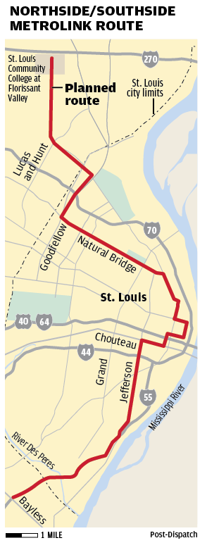
ward24 wrote:Also - want to see progress towards funding this project? It needs to become a political issue everywhere, all the time. In the City, that means the Mayor and in the County that means Steve Stenger.
Hmm...if only there was a currently-serving, non-entrenched alderman who, if elected as Mayor, wouldn't shy away from making the North-South project a priority. Hmm... :)

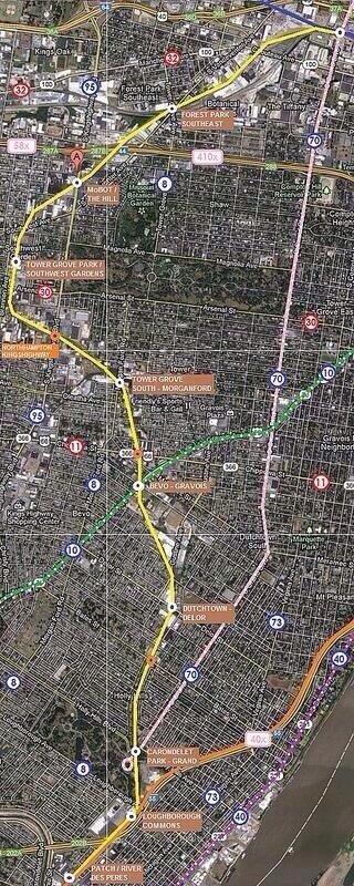
The two southside alignments continue to intrigue me and, while I definitely have a preference, I can see the merits in each. On one side, you've got the Jefferson one that runs on populated streets and through/near popular, stable and -- most importantly -- dense neighborhoods and business districts. There might be some need for demolition when routing but, as Scott said, station stops needn't be overly expensive.

On the other side, you have the DeSoto route and the advantage of existing grade-separated trackage. If the City were able to work out a purchase or long-term lease with Union Pacific (while encouraging existing rail-reliant businesses to relocate along the active Lesperance Line), you could have a ready-made route -- no need for demolition or grading. Neighborhood proximity isn't quite as accessible here as in the Jefferson route, but it's not too far off. Plus, all these former industrial tracts suddenly become ripe for some extensive residential/commercial TOD and Brownfielding IF the City is willing to support the effort.

I know I've posted this about twenty times in the Metrolink threads here, but I love thinking of a fantastical day when ALL of these routes (including a South Broadway exclusive street car) come to fruition. Well, maybe shift the Grand line over to Jefferson, but you get the idea. And maybe in this instance, the DeSoto line exits the ROW near Bevo and continues down on Gravois to hit southwest city and link up with Shrewsbury.


8,155
Life MemberLife Member
8,155

PostNov 14, 2014#724

mill204 wrote: The diagram I drew up below shows half-mile radii from the potential stations. With people like Tom Shrout excepted, studies have shown that the number of people willing to walk to rail transit stations drops precipitously beyond a half-mile distance.

Oh, if only the original line tunneled through to Grand Center & CWE! Instead of their present locations, Metrolink stops at Grand and Lindell and Euclid and Forest Park Parkway would have been killer. I suppose it would be possible to model expected ridership #'s at those much more ideal locations based upon today's population counts. And of course trying to imagine what 30 years of economic development under its belt would have done for these places.

3,547
Life MemberLife Member
3,547

PostNov 18, 2014#725

Editorial: North-South MetroLink expansion could help 'Rebuild St. Louis'

Back in 2008, the proposed north-south Metrolink expansion became one of those billion-dollar ideas put on a shelf to collect dust.

The East-West Gateway Council of Governments, the source of many of the studies that sit on regional leaders’ shelves, had determined that expanding public transportation in the city, and better connecting residential areas north and south of downtown with the central corridor, was a worthy endeavor — even a regional priority.

It should have been. But the thing about regional priorities is that they assume a unified region will agree on them.

link: http://www.stltoday.com/news/opinion/co ... 99e3a.html


Group pushing for MetroLink expansion to connect North & South County

ST. LOUIS, MO (KTVI) - A local group is trying to put light rail expansion back on track in St. Louis.

The coalition that was behind defeating the transportation sales tax is pushing for service to connect North County and South County.

Additional financial support is needed for more studies before the project could move forward.

link (with video): http://fox2now.com/2014/11/18/group-pus ... th-county/

Read more posts (1592 remaining)