Tucker seems like something that the NOW District can embrace in the future if it gets some legs and takes off just as CORTEX embraced some fundamental infrastructure improvement including the new metrolink station and or BJ/Wash U embraced an at grade Kingshighway & FPP intersection. Not necessarily ideal but in this day and age some infrastructure will simply not happen without a quasi public private involvement coming together. Especially in the hyper competitive nature of Federal grants including BUILD grants, so on.
I don't see it. There's no green on the map east of Grand and south of I-64? Are you looking at the earlier study map?GoHarvOrGoHome wrote: ↑Sep 11, 2020Looks like it goes under the Grand Viaduct past the Metrolink station. It's not the most well connected route but will serve as a nice system spine just like the the metrolink ROW that it follows.
Taylor to Boyle section rendering...
![]()
Sent from my iPhone using Tapatalk

Sent from my iPhone using Tapatalk
Not sure if it has been happening or not but considering some of the success with two BUILD grants this time wondering if the region entities can come together with Greenway District and scrounge together a group of projects & funding sources to submit grant app for 2021. The program is popular with Congress and don't see it going away.
Seems, based on GRG online maps, the Hodiamont has been pulled into Brickline. Hodiamont name is no more.
Sent from my iPad using Tapatalk
Sent from my iPad using Tapatalk
- 9,699
GRG has submitted an application for $4,000,000 in FED funds for Brickline construction from
its a $13.85M project with the rest coming from "local" sources
the fed $ is requested starting Oct 1 2023
| SARAH ST TO GRAND AVE SHARED USE PATH (12-14') - BRIDGE OVER VANDEVENTER |
its a $13.85M project with the rest coming from "local" sources
the fed $ is requested starting Oct 1 2023
Disappointed that it’s so far off. I was under the assumption, pre-covid, that much of the Forest Park to Grand was going to fly thanks to private.
Sent from my iPhone using Tapatalk
Sent from my iPhone using Tapatalk
- 9,699
And at that length it's still barely a bike trail. So we're looking at a decade or maybe decades before we have an actual trail that's a rideable distance? Nobody's going out of their way for a half-mile or a mile of trail.
We're on pace to be a decent bike city for our grandchildren. Hopefully my mobility scooter will be allowed.
We're on pace to be a decent bike city for our grandchildren. Hopefully my mobility scooter will be allowed.

Without additional announcements and assuming we’re successful in pending grant request... this is STLs protected network come 2025?
![]()
Sent from my iPad using Tapatalk

Sent from my iPad using Tapatalk
That riverfront trail hasn't really connected to the arch much in the past several years. First it was a closed landing floodwall. Now it's the power plant using the street for long-term storage.addxb2 wrote: ↑Mar 09, 2021Without additional announcements and assuming we’re successful in pending grant request... this is STLs protected network come 2025?
Sent from my iPad using Tapatalk
It's not just the lack of a network, it's that there's a constant fight just to keep that meager network in a functioning format.
If we had a great network, some things be perpetually screwed up would be more acceptable.
 sc4mayorsc4mayor
If you’re just talking about protected off street cycle tracks...but there are dozens of other streets with existing separately marked bike lanes all over the city that could help feed into this larger network. I don’t think I see a single one of those marked here.
If your whole thing is just protected cycle tracks...then yeah you’re probably gonna be disappointed. I don’t think most cities have the money to turn every single bike route into a totally separated little bike highway unless you’re in Copenhagen maybe...
^ To Sc4Mayor point, would have to argue that St. Louis on the plus side with wide streets gives the city a unique position to build a pretty good bike network with simply reducing traffic lanes & good restriping. I can't speak very well too the subject but agree that their is a lot more to it which gets to my next point. What can be done to move things along?
St. Louis with current POTUS admin is probably well positioned if the effort goes into to get some additional funds and grants for expanded greenways and street/pedestrian/bike lane (striping) improvements. Maybe mistaken but things could probably come together quicker with some of these projects once funding is in place. More so than transit and replacing urban freeways. Hopefully a few more grant apps are in the works outside of the above and along the lines of the recent Jeff Ave/21st street improvements awards. An at grade Grand Ave/Forest Parkway intersection as part of a broader scope project to help expand connectivity? and so on?
St. Louis with current POTUS admin is probably well positioned if the effort goes into to get some additional funds and grants for expanded greenways and street/pedestrian/bike lane (striping) improvements. Maybe mistaken but things could probably come together quicker with some of these projects once funding is in place. More so than transit and replacing urban freeways. Hopefully a few more grant apps are in the works outside of the above and along the lines of the recent Jeff Ave/21st street improvements awards. An at grade Grand Ave/Forest Parkway intersection as part of a broader scope project to help expand connectivity? and so on?
Well, they definitely aren't going to build all of that, and the Vandy to Sarah connection, for $14 million, whether it opens in 2025 or 2035.

^And btw, that rendered building east of the Armory...have we seen that before?
It's pretty detailed for a rendering artist just having fun.
It's pretty detailed for a rendering artist just having fun.
It was rendered. Phase 2 of the Armory. May be in that thread somewhereurbanitas wrote:^And btw, that rendered building east of the Armory...have we seen that before?
It's pretty detailed for a rendering artist just having fun.
Am I looking at it wrong, or is the pedestrian bridge going in between the two decks of I-64 (beneath westbound lanes and above eastbound lanes), above Spring Ave? Is there enough clearance space for that?dbInSouthCity wrote: ↑Mar 09, 2021Most of the cost is this bridge
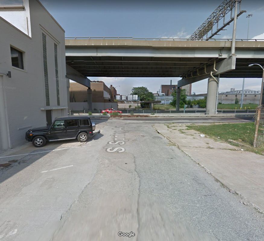
I imagine there's enough space since the Spring Avenue viaduct used to go through there and a pedestrian bridge went through there. Here's a Google Streetview from 2012

In my dream scenario, we'd flood the tracks with a giant lake park stretching from Busch Stadium to the new soccer stadium featuring trails, beaches, swimming and kayak areas. Development would spring up all around the area and many family units would be constructed within close proximity to create a dense, vibrant neighborhood. The sea of parking lots would be a distant, not so fond memory.
I know, it's not going to happen.
I know, it's not going to happen.
- sc4mayorsc4mayor
^ I think you might get that closer to Busch where those huge parking lots are. There would be room for a small pond or lake there. GRG already owns some of those lots if I’m not mistaken...it may take 100 years...but they’ve certainly got some ideas.
^ Sure hope! I would love to see some buildings butting up against the elevated highway on one side with storefronts and outdoor patio areas next to a walk on the other. Beach and lake next to that, the atmosphere during ball games would be awesome.
Does anyone know if McCormack Barron's original Chouteau Lake concept is still alive at any level?
![]()

- 2,683
I personally hope not. I want to see 9th-11th reconnect to Cerre with the parking replaced by a few decent infill apartment projects. With a little foresight the Brickline could weave through seamlessly.