I like this, but it require a way for eastbound 64 to get to SB 55 to access the new toll-free bridge.dweebe wrote: ↑Jul 11, 2025This is very anti-urbanist, but I still think there needs to be a new I-55 bridge that crosses the river by Potomac.
- new bridge is built and could include a rail option
- all truck traffic must use the new bridge and is not allowed in the green part (except local)
- this includes I-44
- truck traffic is allowed in the orange part, but with tolls
- 270 and 255 remain toll free to send truck traffic that way
I really don't think it's a big deal to just remove I-44 south of the Stan Span. Despite that it gets down to just 4 lanes in the depressed section I've not seen a traffic jam, and driving down a boulevard for a mile and a half shouldn't take too long.
- 3,446
How does it currently?jeff707 wrote:I like this, but it require a way for eastbound 64 to get to SB 55 to access the new toll-free bridge.dweebe wrote: ↑Jul 11, 2025This is very anti-urbanist, but I still think there needs to be a new I-55 bridge that crosses the river by Potomac.
- new bridge is built and could include a rail option
- all truck traffic must use the new bridge and is not allowed in the green part (except local)
- this includes I-44
- truck traffic is allowed in the orange part, but with tolls
- 270 and 255 remain toll free to send truck traffic that way
Sent from my iPhone using Tapatalk
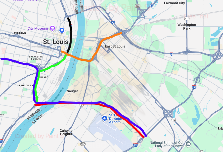
I like it but I would eliminate the green part altogether (and black) and restore the original street grid there to re-link downtown and Soulard and Lafayette Square.dweebe wrote:This is very anti-urbanist, but I still think there needs to be a new I-55 bridge that crosses the river by Potomac.
- new bridge is built and could include a rail option
- all truck traffic must use the new bridge and is not allowed in the green part (except local)
- this includes I-44
- truck traffic is allowed in the orange part, but with tolls
- 270 and 255 remain toll free to send truck traffic that way
Sent from my iPhone using Tapatalk
It doesn't.gary kreie wrote: ↑Dec 17, 2025How does it currently?jeff707 wrote:I like this, but it require a way for eastbound 64 to get to SB 55 to access the new toll-free bridge.dweebe wrote: ↑Jul 11, 2025This is very anti-urbanist, but I still think there needs to be a new I-55 bridge that crosses the river by Potomac.
- new bridge is built and could include a rail option
- all truck traffic must use the new bridge and is not allowed in the green part (except local)
- this includes I-44
- truck traffic is allowed in the orange part, but with tolls
- 270 and 255 remain toll free to send truck traffic that way
Sent from my iPhone using Tapatalk
Understand that it would not fall within Arch - Jefferson Memorial Grounds but i think the low hanging fruit right now would be to do away with the I-44 raised section of freeway north of Wash Ave and convert to blvd. Maybe add 1 to 2 minutes for cars while giving perception of minimal impact. For truckers, maybe you still need to add the extra ramp on Illinois side as Pattimagee noted above. I would assume tthat the I-44 study will cover that, or maybe I'm wrong on that front?
I do think you can add a few more smaller pedestrian lids that would not add to major mechanical ventilation cost or a significant construction cost.
I do think you can add a few more smaller pedestrian lids that would not add to major mechanical ventilation cost or a significant construction cost.
My proposal from a few months back.gary kreie wrote:I like it but I would eliminate the green part altogether (and black) and restore the original street grid there to re-link downtown and Soulard and Lafayette Square.dweebe wrote:This is very anti-urbanist, but I still think there needs to be a new I-55 bridge that crosses the river by Potomac.
- new bridge is built and could include a rail option
- all truck traffic must use the new bridge and is not allowed in the green part (except local)
- this includes I-44
- truck traffic is allowed in the orange part, but with tolls
- 270 and 255 remain toll free to send truck traffic that way
Sent from my iPhone using Tapatalk
addxb2 wrote:This is what I think would have to happen. Illinois would rebuild the 64-70 interchange. Everything between Stan Span interchange and Eads is brought down to a surface level Boulevard. Then tunnel between Olive and Spruce. It would then sort out back on to 64/55.
Interstate traffic would cut into Illinois briefly but traffic could also continue through downtown if they didn’t mind some stoplights and traffic.

Sent from my iPhone using Tapatalk
- 40
It does. In fact, it is part of my commute that I avoid for that reason. I just take Jefferson up to Salisbury instead to avoid it. It is bad from where 70 joins it through the 44/55 split. This is in both directions in the AM and the PM.PeterXCV wrote: ↑Dec 17, 2025I really don't think it's a big deal to just remove I-44 south of the Stan Span. Despite that it gets down to just 4 lanes in the depressed section I've not seen a traffic jam, and driving down a boulevard for a mile and a half shouldn't take too long.
I support putting it underground, and under a lid through all of downtown. remove all elevated sections from Gravois to I70 / Stan span. I have mentioned this before.
I''ve mentioned this before but Eads Bridge should also be permanently shut down to vehicles and redone as a boardwalk and designated as a new national monument within the expanded national park. The bridge is duplicative of MLK and is literally the best physical embodiment of Gateway Expansion the region has. The Arch being a monument to what Eads Bridge actually is. This with a Gondola on the south side of the Arch would probably make this area one of the most photographed areas in the wold. Not hyperbole.


Yes, yes, yes, yes, yes and then we build the amphitheater at the termination in ESL with the stage background being framed by the arch and the STL skyline.addxb2 wrote: ↑Dec 18, 2025I''ve mentioned this before but Eads Bridge should also be permanently shut down to vehicles and redone as a boardwalk and designated as a new national monument within the expanded national park. The bridge is duplicative of MLK and is literally the best physical embodiment of Gateway Expansion the region has. The Arch being a monument to what Eads Bridge actually is. This with a Gondola on the south side of the Arch would probably make this area one of the most photographed areas in the wold. Not hyperbole.
Gemini_Generated_Image_ujasb0ujasb0ujas.png
Gemini_Generated_Image_walwc6walwc6walw.png
- 139
Yup this will be a hill I’ll die on. The bridge is not necessary for cars and it would create an unbelievable space and attraction for St. Louis. It would bring more life to the Landing and the Arch, as well as give the east riverfront a fighting chance. This would be the best pedestrian bridge in the country, the others could not compete. Would be a national drawaddxb2 wrote: ↑Dec 18, 2025I''ve mentioned this before but Eads Bridge should also be permanently shut down to vehicles and redone as a boardwalk and designated as a new national monument within the expanded national park. The bridge is duplicative of MLK and is literally the best physical embodiment of Gateway Expansion the region has. The Arch being a monument to what Eads Bridge actually is. This with a Gondola on the south side of the Arch would probably make this area one of the most photographed areas in the wold. Not hyperbole.
Gemini_Generated_Image_ujasb0ujasb0ujas.png
Gemini_Generated_Image_walwc6walwc6walw.png
It’s right there for the taking
- 2,075
^imagine sitting on the Eads bridge watching the fireworks, running across it for the GO marathon, wedding photos... my lord it would be amazing... and great for city marketing/photography
Agree on the no need for cars and would even argue you could say the same for MLK bridge if they redo Poplar & ramp configurations. Great reuse of Eads bridge and way to expand park & trail system.
Tricky part is who owns it and committing to maintenance? Obviously you got metrolink/bi state involved at the moment. Not sure how it is currently managed by MoDOt (if any involvement), City, BiState, as well as Illinois side of things. Anyone with good understanding if current status?
Tricky part is who owns it and committing to maintenance? Obviously you got metrolink/bi state involved at the moment. Not sure how it is currently managed by MoDOt (if any involvement), City, BiState, as well as Illinois side of things. Anyone with good understanding if current status?
My recommendation would be to reroute MLK on to Broadway in East St. Louis near where the Route 3 expansion is. Then destroy all the exits MLK exits from the interstates and make it the auto connection for East St. Louis to Downtown St. Louis. There is no reason the interstates need to be connected to MLK when Stan and Poplar exist. MLK should be local traffic only.
- 343
Getting off topic a bit, but can anyone explain why the MLK bridge has both right and left exit lanes from 55/64? Is it just to accommodate the on-ramp from St. Clair Ave? I can't imagine that sees much traffic these days. Kind of a product of a bygone era.
- 6,157
I believe it's owned by the city in conjunction with Bi-State. It was originally owned by the Terminal Railroad Association, but the TRRA had no use for it anymore, thanks to the height of the tunnels, so they traded it to the city in exchange for the MacArthur (or Municipal "Free") Bridge, which the city no longer needed. It was a win win for both parties.dredger wrote: ↑Dec 18, 2025Agree on the no need for cars and would even argue you could say the same for MLK bridge if they redo Poplar & ramp configurations. Great reuse of Eads bridge and way to expand park & trail system.
Tricky part is who owns it and committing to maintenance? Obviously you got metrolink/bi state involved at the moment. Not sure how it is currently managed by MoDOt (if any involvement), City, BiState, as well as Illinois side of things. Anyone with good understanding if current status?
There's some remarkably interesting old railroad history tied into our trio of railroad bridges. They were the data centers of their day, and they burst as thoroughly as the dot com bubble. (The fights over government support were doubtless also similar.)
^4 railroad bridges, if you count that Mckinley used to be one too.
- 2,661
One of the most important aspects of this Eads Bridge linear park is having something on the other side worth crossing to. Right now there is basically nothing apart from the casino over there. There are two attainable solutions:
#1: This is perhaps the lowest hanging fruit, but connecting the Eads to bike networks on both sides of the river. It should be the nexus of the interstate bike network. On the STL side, the Eads should be rolled into the Brickline as it's premier extension of the early 2030s. It would also be connected to the North Riverfront Trail.
The Illinois side has a much more extensive network to connect to, but final connections have to be made.
-The MetroBikeLink trail is the most obvious as it already has long term plans to connect to the Eads. It just has to be built through Washington Park and East St. Louis. I would also argue that it could be rolled into the greater Brickline marketing. It would be super cool to have a cohesively branded single trail that goes between Mid-America and Forest Park.
-Other important connections: Connecting the bike path on Front Street about 1.5 miles north to the Confluence trail at the McKinley Bridge, then getting the Schoolhouse Trail the final mile to connect at the same location.
With these projects completed the Eads could be the beautiful keystone on our bike network. It would force a decent amount of non-vehicular traffic across every day AND help with the success of the next project.
#2: Redevelop the East Riverfront with dense and mixed use development. I don't care how many tax incentives need to be thrown at this, it needs to happen. It's not hard to imagine it succeeding: great views of the Arch and Downtown, central location, and access to Metrolink. Access to the center of the regions bike network if the above happens. 5,000 residents living right across the bridge should be enough.
An amphitheater around here would also be fantastic.
Downtown East St. Louis also eventually needs to be redeveloped. This will obviously be a tougher cookie to crack but once again there should be tons of incentives thrown into getting this going.
- 2,075
^I'd also add that the note about extending the national park across the river would be a welcome first step also
I agree, as soon as demo started on Millennium, this gained a lot of steam very quickly. Fingers crossed.dbInSouthCity wrote: ↑Dec 16, 2025I think this is much closer than people think
Yes, I think the National Park with significant improvements would be necessary but imagine the combinations of river crossing available if Eads was pedestrian+MetroLink, gondola on the south end, river ferries across. You could spend the whole day just experiencing different river crossings providing stunning views of North America's Eiffel Tower. Imagine if the River was lined with dinner boats like Paris and Chicago.pattimagee wrote: ↑Dec 19, 2025^I'd also add that the note about extending the national park across the river would be a welcome first step also
Again, easily one of the most photographed and recognized places in the world in less than a decade.
- 6,157
True. I think I missed that because I was thinking in terms of the national network, of which IT was only very peripherally a part. Any railroad could pay to use Merchants, Eads, or MacArthur. I'm not sure anyone other than IT ever used McKinley. There was also a CB&Q owned bridge in Alton that they used themselves and a few other railroads might have viably used via trackage rights, though I'm not even sure if the Q routed any of their passenger service over it. (They certainly could have. Probably at least some local service.) There's a number of interesting bridges, really. But the Eads, Merchants, and MacArthur are all closely linked both historically and physically in a way the others aren't. (Even if the city owned the MacArthur, the TRRA pretty much always dispatched it, making each a viable routing for most trains crossing the river.)PeterXCV wrote: ↑Dec 19, 2025^4 railroad bridges, if you count that Mckinley used to be one too.
- 3,446
- 534
Seems like a large sinkhole opened up under the highway near Lumiere.