there is a new site plan of this from April 2016
Update from nextstl
https://nextstl.com/2017/04/300m-lighth ... ves-ahead/
I really can't believe this might still happen but it looks like a fun setup. I with they had something like this a closer to downtown but I hope it is successful. It is nice to see someone use the river in the development. It would also be nice to see this done for the people living in North City/County to have something closer to them.
It is a very interesting (if a bit suburban/parking lot-ish in design) proposition. I genuinely like the idea of a marina that can double as a tourist/entertainment destination. That's a niche that really has yet to be filled on our stretch of the Mississippi.
But this commenter from the NextSTL update has a point:
This is an opportunity for folks to put their boat a few hundred yards upstream from an "extremely difficult and dangerous" water hazard. You'd likely have sufficient clearance in something with a shallow draw like a john boat, but there are very strong currents that a little boat could struggle to deal with. Larger boats are in real danger of bottoming out on some fairly sharp rocks.
They're going to have to make it plainly obvious that it's dangerous to motor downstream, and even then I'm sure there'll be some who launch from the marina and ignore the warnings; they could easily end up in a life-threatening situation.
-RBB
But this commenter from the NextSTL update has a point:
The Army Core of engineers calls the Chain of Rocks Reach "a 17 mile series of rock ledges ... extremely difficult and dangerous to navigate."Justin Wolfe • 20 hours ago wrote: Who ever thought it is a good idea to put a marina above the chain of rocks hasn't thought this one through.
This is an opportunity for folks to put their boat a few hundred yards upstream from an "extremely difficult and dangerous" water hazard. You'd likely have sufficient clearance in something with a shallow draw like a john boat, but there are very strong currents that a little boat could struggle to deal with. Larger boats are in real danger of bottoming out on some fairly sharp rocks.
They're going to have to make it plainly obvious that it's dangerous to motor downstream, and even then I'm sure there'll be some who launch from the marina and ignore the warnings; they could easily end up in a life-threatening situation.
-RBB
- 8,930
This will be a popular stop for boaters if they have a restaurant, marina, fuel and overnight accommodations.
Every boater will know about the chain of rocks hazard. This is a not far out of the way for boaters making "the great Loop" as it's right around the corner from the chain of rock canal.
http://www.greatloop.org
There are some marina's up in Alton and over in Portage de Souix , st Charles etc and some cool resort areas like Chautauqua and lock haven.
This will be the only stop between Alton and Hoppiea marina in Kimswick.
Abandon ship/barge/island!framer wrote: ↑Feb 21, 2018More curious goings-on:
http://www.stltoday.com/news/local/colu ... e8878.html
- 1,864
How the heck can people with previous fraud, embezzelment, and extortion convictions get city handouts for a multi-million dollar flood plain boondoggle... and yet I can't even get my student loans refinanced. 

- 6,163
^Heh! It's not what you know it's who you know? Story of what's wrong with our society in a nutshell.
- 3,823
https://www.bizjournals.com/stlouis/new ... 2022-09-07
Lighthouse Point is still being pitched apparently. I'd like to see a developer finally solve the North RF first.
Lighthouse Point is still being pitched apparently. I'd like to see a developer finally solve the North RF first.
- 1,641
More marinas, from 270 to 255! Any activation of the riverfront is better than what we got.
- 2,419
A project like this feels out of place where they're proposing it, but I'd love to be proven wrong.
Could we see some improvements to the Old Chain of Rocks Bridge with this?
It's already such a great place to take a walk and watch the river, but I really think the potential is there to make that bridge a full-blown destination.
Could we see some improvements to the Old Chain of Rocks Bridge with this?
It's already such a great place to take a walk and watch the river, but I really think the potential is there to make that bridge a full-blown destination.
- 991
It makes the most sense location wise if they're pitching a marina, especially since shipping traffic uses the canal. This is one of the only stretches of river where boaters don't have to constantly be looking out for barge traffic.
- 2,419
Good point. Pleasure boatin' ain't pleasurable if you're worried about barge traffic.
So then I'd like to double down on my Old Chain of Rocks Bridge idea by making Chouteau Island a recreational refuge from the city.
It already kind of is, but there is clearly more that could be done with it -- especially in conjunction with improvements to the bridge.
So then I'd like to double down on my Old Chain of Rocks Bridge idea by making Chouteau Island a recreational refuge from the city.
It already kind of is, but there is clearly more that could be done with it -- especially in conjunction with improvements to the bridge.
https://www.stltoday.com/business/local ... 2b9a8.html
If this article from 2015 is any indication, I may get my wish in part.
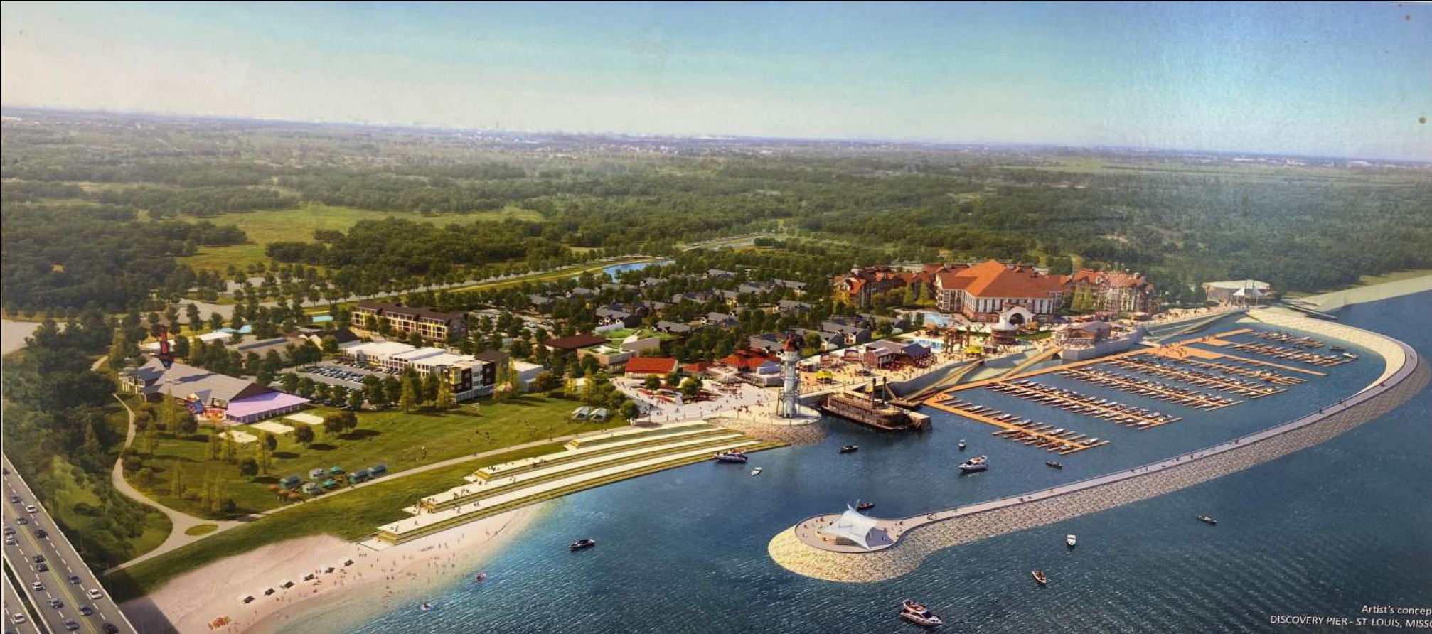
"Included in the planned first phase is a gas station, convenience store, boat ramp, visitors’ center, restaurants, an event center, a hotel and a lighthouse perhaps 60 feet tall.
The $55 million first phase also would have a bike trail connection to the Great Rivers Greenway’s Riverfront Trail that crosses the Mississippi over the Old Chain of Rocks Bridge."
If this article from 2015 is any indication, I may get my wish in part.
"Included in the planned first phase is a gas station, convenience store, boat ramp, visitors’ center, restaurants, an event center, a hotel and a lighthouse perhaps 60 feet tall.
The $55 million first phase also would have a bike trail connection to the Great Rivers Greenway’s Riverfront Trail that crosses the Mississippi over the Old Chain of Rocks Bridge."
^ & ^^, YEP, total agree that a marina upriver of downtown & the locks in pooled water makes a whole lot more sense for pleasure, recreational boater then a roaring, high current, heavy traffic/industrial river running through downtown. It dangerous enough for professional who make a living on those barge tows let alone a pleasure boater.
- 3,464
2 questions. Does the rock layer in the chain of rocks make a sort-of underwater dam that allows water to pool lake-like around the I-270 bridge? And would it be possible extend a lengthwise jetty from lock 27 all the way to middle of the poplar street bridge, where it Ls into a low water dam that pools & slows water lake-like in front of the Arch?
Sent from my iPhone using Tapatalk
Sent from my iPhone using Tapatalk
Just watch out for the Chain of RocksLaife Fulk wrote: ↑Sep 07, 2022It makes the most sense location wise if they're pitching a marina, especially since shipping traffic uses the canal. This is one of the only stretches of river where boaters don't have to constantly be looking out for barge traffic.
- 2,419
That walkway out into the Mississippi River is the stuff dreams are made of.
Seriously hope this happens.
Seriously hope this happens.

- 6,163
Yeah. In fact, Chain of Rocks is the specific (half natural) low water dam that creates that very pool.gary kreie wrote: ↑Sep 08, 20222 questions. Does the rock layer in the chain of rocks make a sort-of underwater dam that allows water to pool lake-like around the I-270 bridge? And would it be possible extend a lengthwise jetty from lock 27 all the way to middle of the poplar street bridge, where it Ls into a low water dam that pools & slows water lake-like in front of the Arch?
Sent from my iPhone using Tapatalk
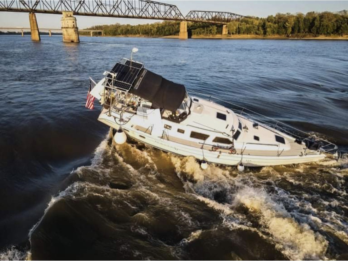
Didn't they lose power? I think they knew it was coming, but couldn't get the boat moving to avoid it. If the river had been marginally higher at the time they'd have just cleared it and kept on going.sc4mayor wrote:Just watch out for the Chain of RocksLaife Fulk wrote:It makes the most sense location wise if they're pitching a marina, especially since shipping traffic uses the canal. This is one of the only stretches of river where boaters don't have to constantly be looking out for barge traffic.
^ I’m actually not sure, I was being facetious for the most part haha. Provided the water levels are high enough to clear the low water damn by several feet, recreational boats won’t have any issues there. Good place for a marina if one should end up in the city limits.
Edit: I also know a few folks that take recreational boats out on the Missouri, this is a pretty great location in terms of access to the confluence.
Couple more pics I saw in the BJ today:
![]()
![]()
Edit: I also know a few folks that take recreational boats out on the Missouri, this is a pretty great location in terms of access to the confluence.
Couple more pics I saw in the BJ today:

