Decided to make another, more realistic, map of how I might lay out some future transit lines in St. Louis. The first one I did was a bit more fantasy and I posted it in the
Transportation Catch All thread, but didn't want to take that thread too far off topic. This seems like a good enough spot.
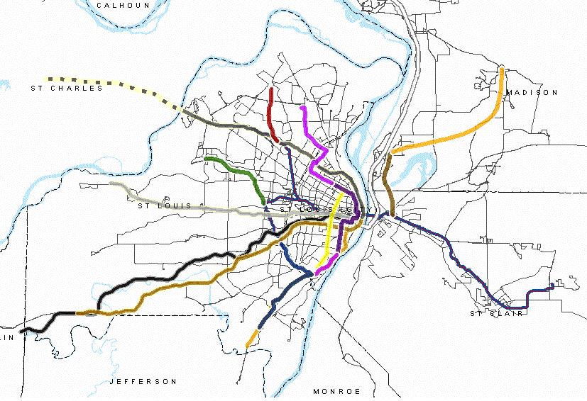
Made quite a few changes from the first map that I'll detail a bit more below. I split the system up into three divisions; Urban, Suburban, and Regional and switched the orientation back to the more traditional north/south view I think most of us view the region in. Illinois will come a bit later. Here's the map...right click, view in new tab should get you some decent zoom:
![]() Urban Division:
Urban Division:
The Urban division has four lines (Yellow, Orange, and Green A/B). The Yellow line remains the Cross City line, running from Spanish Lake to South Broadway with no direct downtown service. The Orange line runs from Florissant Valley to downtown. The Green A/B lines split at Grand and Gravois. Line A continues down Grand and Lemay Ferry to Mehlville Terminal. Line B continues down Gravois to Affton. Once the Green and Orange lines meet on Jefferson, they turn east and run down Olive to 8th over to Spruce then to 14th and back to Olive creating a downtown loop that would connect with the existing 8th & Pine, Stadium, and Civic/Gateway stations.
The rolling stock can be left up to your imagination. It can be ART, BRT, LRT, or STC. I tried to design this somewhat in line with what is likely to be proposed in the near future with N/S (my routings are obviously a bit different). There is really no chance it's going to be the high floor vehicles that we use on the existing lines...so whether it's low floor street running LRT or BRT or something else, the lines I've drawn in this division don't require sharing any trackage with the existing MetroLink.
Suburban Division:
This one is pretty self-explanatory, it's just MetroLink! Like I said, I kept the original alignment this time around and the extensions mapped out here (Turquoise, Silver, and Blue) largely track (heh) with Metro's older long range plan. I did eliminate the Blue Bird commuter rail in favor of the Turquoise line that runs from downtown to Sunset Park in Florissant. It would divert from the Red line at the 70/170 interchange...where Metro has already partially started the flyover. The Silver, or Cross County, line would run from the Airport to Mehlville Terminal, which is also where the Blue line extension would end. I shifted these two lines into the BNSF corridor for a more direct route to South County and I routed the Cross County line to the Airport instead of Florissant because I think a one seat airport ride from Clayton is ideal. Lambert Junction was created to facilitate transfers between those three lines for airport and other users. There would be no ground access at that station, simply a transfer between the Red, Silver and Turquoise lines.
Speaking of other MetroLink extensions...I did note the funded and coming MidAmerica expansion in Illinois on the key. It'll make into an Illinois map eventually.
Regional Division
I personally think a commuter rail system as envisioned here is quite unlikely for the St. Louis region, even if I think it might be cheaper and more politically feasible in faraway places like St. Charles, etc. But it's fun to think about, so I kept it. Biggest change here, aside from the removal of the Blue Bird, was changing all the Missouri lines to pink. Eventually I'll get around to mapping out Illinois and I have some commuter rail ideas there...those lines will be purple. I extended the Cannon Ball to Washington as well. Pulled the fantasy Central Exchange station I had originally put downtown and just ended these lines at the existing Gateway Station. Though I would imagine a multi-line system like this would require a larger station...or a least a couple more platforms.
I did take @symphonicpoet's advice on a couple of the MoPac names too! The Pacific was switched to the Scenic and the Frisco to the Firefly.
You'll notice I did keep out the Westport MetroLink extension in favor of the Cannon Ball commuter rail line. Despite Westport being a regional attraction and having a significant number of jobs, I just think it's too sprawled and too industrial in nature to be worthy for an expensive light rail investment. I think the Cannon Ball line depicted here combined with robust shuttle and bus service (or other last mile services) can provide service to Westport, Creve Coeur (City and Park), 39 North, Old Olive, and more.
Other:
As before, I did note a few other things on the map. Mostly some high-frequency bus lines and various greenway and cycling connections. I added several more than I did the first time around too. Most of the greenways depicted here are already completed. I also drew out the funded and soon to start Tower Grove/Vandeventer/Sarah and 20th Street cycle tracks, plus the planned Tucker track and a potential connection to the Trestle. There could be dozens more of these (like Brickline) but I didn't want to clutter the map too terribly much.
Like I said in my last map post...high-frequency buses don't have to be BRT or anything fancy...just buses that run every 10 minutes or so. Proposed routes depicted here:
Washington/MLK/Rock Road
14th/West Florissant/Jennings Station/367
14th/Chouteau/Manchester
4th/7th Boulevard/South Broadway
Grand Boulevard
Kingshighway/Morgan Ford
Wabash/McCausland/Skinker/Jennings Station/367
Jamieson/Hampton/Germania
Lindbergh Boulevard
Gravois (south of Affton Station to Gravois Bluffs)
If I think of some more notes I'll add them.
Enjoy!