the photo source is irrelevant, hence why i just posted it straight from the google list instead of save and host at tinypic. even then someone savvy enough could do a reverse image search, but again, the source is irrelevant. instead of getting upset about the photo, get upset about the sh*tty job metro is doing serving the transit needs of the region.
Better for the Transportation where do we go from here thread, but I'll bite nonetheless.
The sh*tty job was done by the people who sprawled out our region then mandate that Metro try to serve it.
The sh*tty job was done by the people who sprawled out our region then mandate that Metro try to serve it.
- 9,699
Oh please, Metro serves the city and STL county on our side of the River..take KC or some other like cities and use their sq mileage and transpose it over the city and STL county, it would take up everything isnide 270 and some more.
Is St.Charles sprawl and unnecessary? Yes but it's a strech to say that anything in st.louis county is spawl....in my book, everything inside 270 is the city and inner right suburb is everything else around in st.louis county
Is St.Charles sprawl and unnecessary? Yes but it's a strech to say that anything in st.louis county is spawl....in my book, everything inside 270 is the city and inner right suburb is everything else around in st.louis county
- 8,155
Can we get this thread back to actual Saint Louis Transit Photos? Thanks!
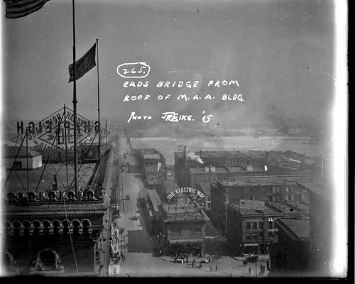
A comparison of Eads Bridge transit infrastructure Then and Now:
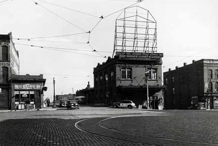
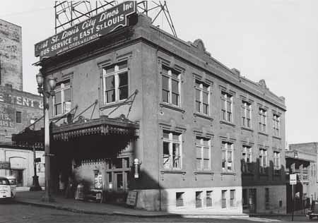
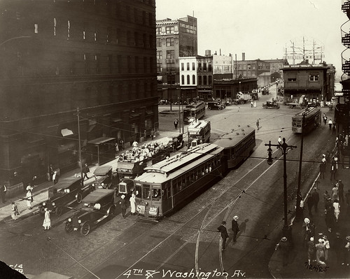
This little station was actually the terminal for all of the streetcars coming over from the East Side:
![]()
![]()
![]()
![]()
All historical images from VanishingSTL which did a great series of pieces on this stretch of Wash. Ave. The link goes directly to Pt. 2 of that series.
![]()
![]()
![]()
![]()
I'm not sure which station I like more. The sign on top of the old streetcar terminal is killer (its awning is pretty great too). But the subway-to-bridge arch-view combination for the Metrolink is pretty fantastic (the combination of old brick/stone with modern concrete construction is good too). If someone put a huge "The Electric Way" sign on the side of the Eads Bridge over the station entrance there'd be no debate.
This little station was actually the terminal for all of the streetcars coming over from the East Side:
All historical images from VanishingSTL which did a great series of pieces on this stretch of Wash. Ave. The link goes directly to Pt. 2 of that series.


I'm not sure which station I like more. The sign on top of the old streetcar terminal is killer (its awning is pretty great too). But the subway-to-bridge arch-view combination for the Metrolink is pretty fantastic (the combination of old brick/stone with modern concrete construction is good too). If someone put a huge "The Electric Way" sign on the side of the Eads Bridge over the station entrance there'd be no debate.

I'm pretty sure I posted this in another thread, but can't remember exactly where:
![]()
^That looks like the roofline of the Gokul Indian Restaurant building to the far left.
Here's another shot of the old Delmar Station (prior to construction of the limestone beauty). It's kind of amazing to think that there have been three different train stations at this location in the last hundred years including the current Metrolink station. There's quite a rich history of Delmar/Loop transit - notwithstanding its important role as a streetcar terminal. Apologies for the "water mark".
![]()

^That looks like the roofline of the Gokul Indian Restaurant building to the far left.
Here's another shot of the old Delmar Station (prior to construction of the limestone beauty). It's kind of amazing to think that there have been three different train stations at this location in the last hundred years including the current Metrolink station. There's quite a rich history of Delmar/Loop transit - notwithstanding its important role as a streetcar terminal. Apologies for the "water mark".

Say, Wabash, think you can dig up an image of that crazy old train station along the river somewhere on the Southside with the stairway going up the bluff? I think it may have been the Iron Mountain Railroad, but I'm not sure.
I'm not exactly sure which station you mean, but it sounds great. It sounds like it'd be along the same line as the Jefferson Barracks station posted above. I'll keep looking and see if I can track it down.
There are a few other abandoned stations around St. Louis (and beyond) that have stairways up bluffs:
This station in Kirkwood along the Frisco line used to serve the Meramec Highlands resort.
![]()
![]()
It was repurposed into a house in 2006:
![]()
Also, the Amtrak station in Poplar Bluff (which used to be on the St. Louis & Iron Mountain Railroad) has a station with a grand staircase directly behind it:
![]()
![]()
![]()
(The decay on the stairs reminds me of the old walls along Forest Park Parkway, the balustrades at Union & Lindell, and a lot of other masonry around Forest Park before Forest Park Forever swung into action).
There also used to be a station at Castlewood in West County that was right on the Meramec, with a building across the tracks overlooking the river:
![]()
There are a few other abandoned stations around St. Louis (and beyond) that have stairways up bluffs:
This station in Kirkwood along the Frisco line used to serve the Meramec Highlands resort.


It was repurposed into a house in 2006:

Also, the Amtrak station in Poplar Bluff (which used to be on the St. Louis & Iron Mountain Railroad) has a station with a grand staircase directly behind it:


(The decay on the stairs reminds me of the old walls along Forest Park Parkway, the balustrades at Union & Lindell, and a lot of other masonry around Forest Park before Forest Park Forever swung into action).
There also used to be a station at Castlewood in West County that was right on the Meramec, with a building across the tracks overlooking the river:

Great shots, but not the one I'm thinking of. There was a really scary-looking wood stairway zig-zagging up the bluff behind the station. Pretty sure it was somewhere south of Downtown, along the river.
Based on this link, I wonder if the station you're looking for is Carondelet or Robert Ave. Depot. I can't find any photos, though.
Or perhaps it was the Plum St. Depot at 1st and Plum. But I can't find any images of that either. It'd be long gone, of course. Here's a drawing.
http://model-railroad-hobbyist.com/node/17312
Or perhaps it was the Plum St. Depot at 1st and Plum. But I can't find any images of that either. It'd be long gone, of course. Here's a drawing.
http://model-railroad-hobbyist.com/node/17312
I think I found it. You weren't kidding, it's both crazy and scary-looking. It was located at 4078 S. Broadway in the Mt. Pleasant neighborhood.
A website with some back-story states that: "In a pictorial review of American railroad stations from 1831 to 1920, the author nominates Tucker’s station 'as the most unusual of all suburban stations.' A picture of the station was used in an advertisement for the American National Bank accompanying the picture were the statements - 'this must be the most unusual station ever built' and 'the south St. Louis bluff side station was unlike any other – before or since!'"
![]()
![]()
A website with some back-story states that: "In a pictorial review of American railroad stations from 1831 to 1920, the author nominates Tucker’s station 'as the most unusual of all suburban stations.' A picture of the station was used in an advertisement for the American National Bank accompanying the picture were the statements - 'this must be the most unusual station ever built' and 'the south St. Louis bluff side station was unlike any other – before or since!'"


That's it! Even crazier than I remember. Obviously, this was built long before the Americans with Disabilities Act.
More old shots of the Delmar Wabash train station:
![]()
(Courtesy of Lew Schneider)
![]()
(Courtesy of Lew Schneider)
Things have certainly improved since this shot was taken in 1988:
![]()

(Courtesy of Lew Schneider)

(Courtesy of Lew Schneider)
Things have certainly improved since this shot was taken in 1988:

Market just east of Vandeventer in the early 1950's:
![]()
Credit: TheOldMotor.com
And in 2012:
![]()
Central Ave in Downtown Clayton in 1959:
![]()
Credit: NextStopSTL
And in 2012:
![]()
It looks a little more spruced up now, but other than the streetcar, it's amazing how little has changed.

Credit: TheOldMotor.com
And in 2012:

Central Ave in Downtown Clayton in 1959:

Credit: NextStopSTL
And in 2012:

It looks a little more spruced up now, but other than the streetcar, it's amazing how little has changed.


^ Forest Park Pkwy rebuilt completely from scratch and they 1) failed to make its intersection with DeBaliviere ADA compliant, and 2) prohibited walking to the station from Pershing west of the Red Line.
- 9,699
you sure it wasn't ADA compliant at the time it was built? ADA compliance changes like 3 times a month.mill204 wrote:^ Forest Park Pkwy rebuilt completely from scratch and they 1) failed to make its intersection with DeBaliviere ADA compliant, and 2) prohibited walking to the station from Pershing west of the Red Line.
Yeah, this one really burns me up as well. And we're not the only ones. An informal foot path has developed between Pershing and Forest Park Parkway, and because the gate is padlocked, the fence has been pried open to allow people to squeeze through.mill204 wrote:Forest Park Pkwy rebuilt completely from scratch and they... prohibited walking to the station from Pershing west of the Red Line.

I found this on a website dedicated to historic streetcars in different American cities. The caption says "St. Clouis PCC 1659 on Hodiamont on July 8, 1961." Anyone have any idea exactly where this was taken? My guess would be Downtown Wellston, but I can't pinpoint where this would have been:
![]()

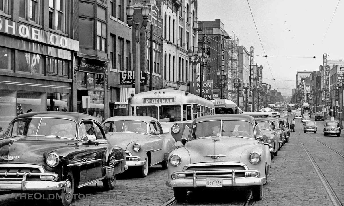
Not sure, but this photo is very close. The caption says "Market Street between 6th and 7th, 1953". There's a Stein's sign in the background, and the light poles look the same, but there's a Delmar bus, so I don't know. Both great shots, though.
http://theoldmotor.com/?p=64452
http://theoldmotor.com/?p=64452
- 8,155
^ good catch... here is the photo
![]()
this is the same location about a decade later as you can also see the Globe in both photos and the light posts are the same.... it appears that a demo of several buildings to the Stein's side of the street had occurred in the period betweem the two photos. I think your photo does show this is indeed downtown as the scale and density is too great to be Wellston or Delmar Loop.
edit: while I think it is downtown, it doesn't resonate with me as being between 6th & 7th on present day Market. But there is a 608 address in the photo so it is driving me crazy.... I'm wondering if maybe this was more on the northern part of downtown where the convention center is now and that may align more with the Delmar line.
^ okay, I'm pretty sure now that they were mistaken about Market being called Franklin.... Franklin indeed did run through the present-day convention center/dome site and it later was re-named MLK Drive (before running along what was formerly known as Easton Ave.)
So I'm 99% sure this is where the Ed Jone Dome is now.... and then there is this historical image of Frankin Avenue
![]()
So I'm 99% sure this is where the Ed Jone Dome is now.... and then there is this historical image of Frankin Avenue