^I'm assuming he's responding to the location in the old NextSTL article.
I thought the thing that kept this one from getting across the finish line was to get the Port Authority to change their borders to include this so they can levy additional taxes for the site? or something like that...
I'm not sure I see anything that would even be open for that at least until you get down to River Des Peres or or By River City Casino? Everything else looks blocked up?
Yeah, I wasn't confident in his story. I actually wondered if his location might have been off. I wondered if maybe it was really a little further north but completely speculative on my part.
If I understand correctly from some other folks posts a lot of the barges are just moored for storage waiting for seasonal use, so in theory you could move them somewhere else easily enough. Maybe Dredger could say better. Everything between Barton and about Rutger looks movable. You wouldn't have a terribly wide beach outside the floodwall, but you probably don't need much, and maybe you can build a marina so if it floods it's no huge deal. They even repaved some or all of Wharf a few years ago. You'd be going in and out through a lot of industry, but I expect it's honestly pretty quite save for the trains. There's just nobody down there. I'd think a well lighted sight with a watchman would be fine. Heck, there's already at least some security for the yards and wharfs. I can't imagine a cabin cruiser is all that much more expensive than the towboats and locomotives that are there already. Just a different use.
In Short, "In response, the federal government awarded the county $56.4 million and the city $25.8 million in recovery money. These governments now need to craft action plans to spend it. One eligible investment they can show support for is a study on the feasibility of “river restoration”—that is, the daylighting and regreening of River Des Peres."
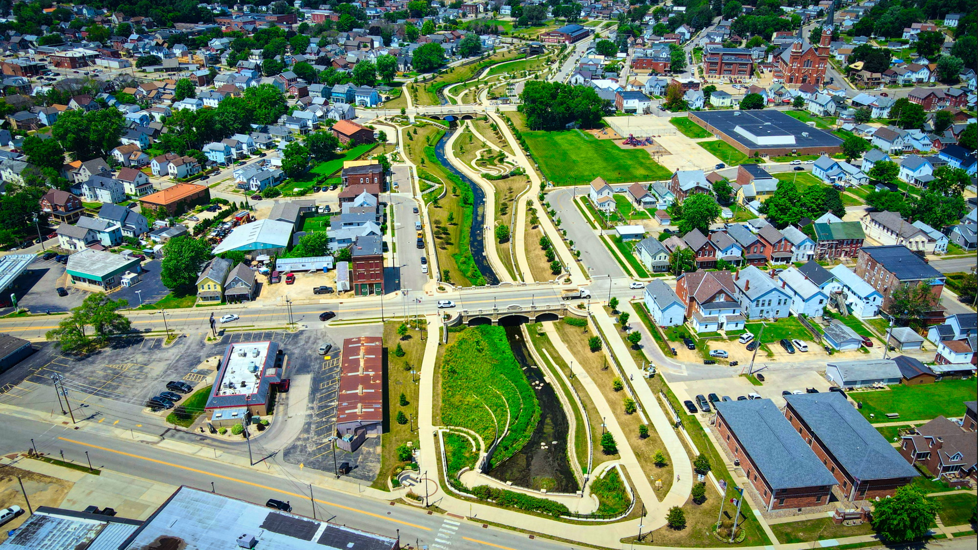
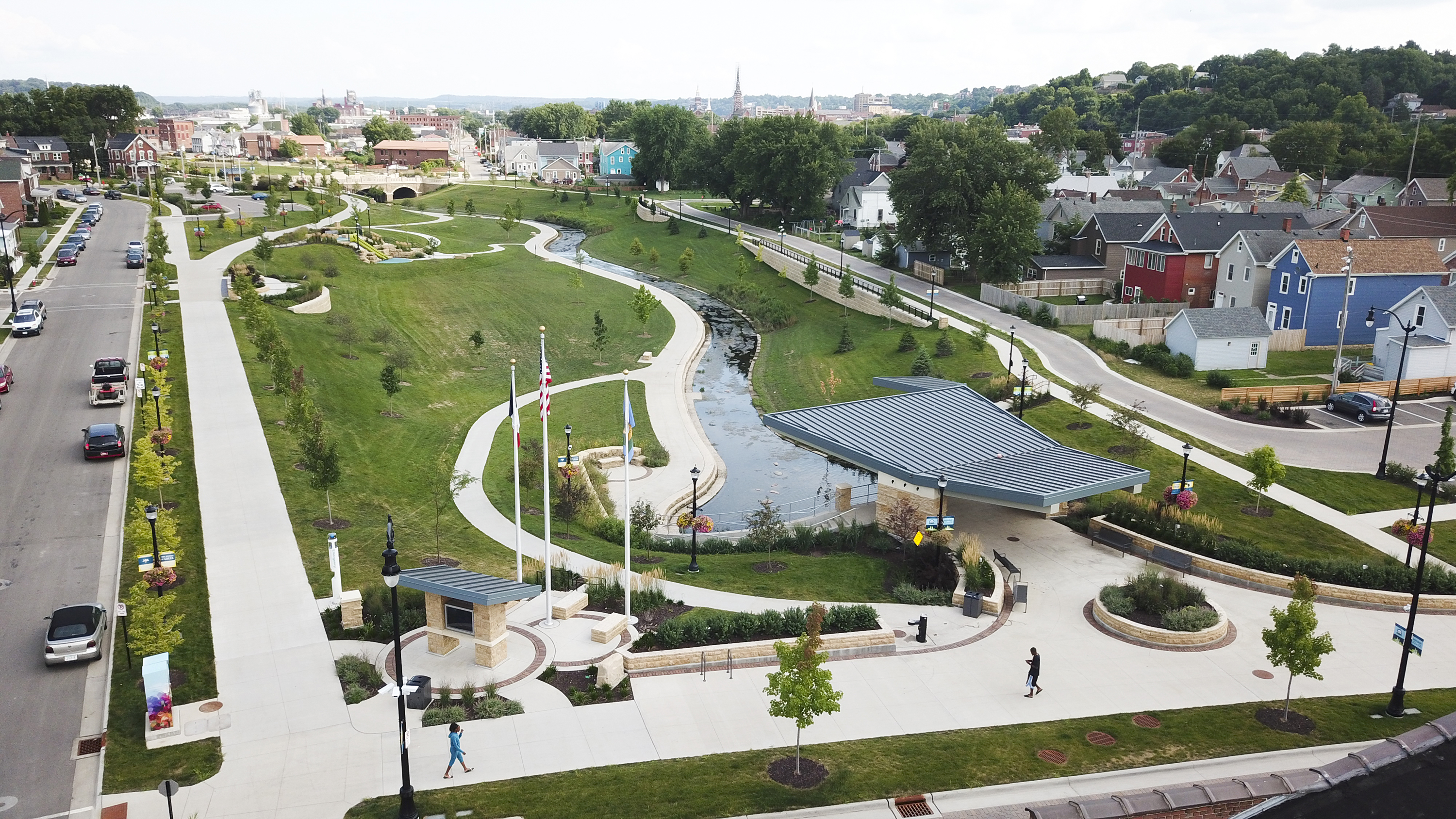
Another interesting piece of that article was that the BOA has already discussed this possibility, "In December, a Board of Aldermen committee hosted Brad Cavanagh, the mayor of Dubuque, Iowa. He gave a presentation on what his town has done with its Bee Branch watershed—a rough analogue to St. Louis’ RDP watershed."
The Bee Branch Watershed is approximately 6.5 square miles stretching from the Mississippi River west past John F. Kennedy Road, north to the Northwest Arterial, and south to West Fifth Street.
It would be nice if we could repurpose some of the old stone maintenance buildings along River Des Peres into small brewery outposts with food. Tie it into the trail out to Grant’s farm and brand it as the beer trail or something.
^the one thing about this idea is that it seems more "reasonable" or "doable" and different than the River Des Peres rowing or yacht club dreams that involve a dam, haha (I would all for a big proposal doing that too)... I also love the idea of mitigating runoff dramatically up hill from the river so the peaks aren't so crazy...
I think if you are digging out the channel you can increase the amount of water it can hold while also adding catch basins in strategic locations. I would imagine engineers would plan where different types of structures go based on reoccurrence of large water events - like you wouldn't put walkways where yearly events happen.
Also, I believe they planted specific plants on the arch riverfront that can hold their root-base during floods and then return after the water recedes... just looked it up, "Blue Dune Lyme Grass tolerates sun, sand, erosion, and drought. Great for urban and coastal environments."
The engineering aspects of this are three feet over my head, but as a resident of this area I would gladly welcome any/all ideas to spruce up the RDP from what is presently a glorified drainage ditch that's empty 95% of the time. Not sure about damming it; it definitely serves it purpose the 5% of the time its in use, But again, not an engineer or developer, so maybe I'm just missing something.
^ Have to agree with those thoughts as someone who used to live nearby, Shrewsbury, and ran a few miles up and down the path next to it.
No need to dam anything. Just getting Lower River Des Peres to actually be a river again instead of a massive drainage ditch (including the underground ditch no one sees) would be a monumental improvement in its own right. Start with getting Deer creek floodway, greenway expanded from Brentwood to its confluence with River Des Peres. From there, remove the River Des Peres drainage infrastructure to start restoring to its natural state.
I really think one way you get back to an urban walkable areas in a land rich city, metro area with cheap land values is start by getting some natural features back to their natural state. River Des Peres could be a huge asset to the area once you can restore its natural state as well as letting the natural state take some of the flooding risk, flooding mitigition.
Dubuque has something cool going there but the River Des Peres is much longer. IMO a refreshed RDP (South of 44) should resemble something closer to the Buffalo Bayou in Houston, the South Platte River in Denver, or the Trinity River Valley in Dallas.
The valley should green and pleasant place to walk, the river itself should be narrowed and have the form of an actual natural stream instead of a storm drain. Landscaping should be designed to flood and drain without without problem during periods where extra capacity is needed
Was looking into how impressive the Dardenne Creek Blueway is out in St. Charles County and was thinking about how neat it would be if St. Louis city and County could have something similar.
River Des Peres and its tributaries like Deer Creek and Black Creek seem like they could be the best candidate for something similar.
Would it be too expensive? Too dirty? Too dangerous? Too unsavory for nearby St. Louis County residents that have had their homes flooded? Water levels too inconsistent?
^ I always thought Deer Creek has the makings of a great little side greenway when I lived nearby once upon a time but a big part of it comes down to consensus & cost as I can think of a few costly properties in Maplewood and Webster Grovers that would need to be bought out and relocated just get the breathing room & space that Brentwood created for a even a small portion of Deer Creek running through/next to Manchester Blvd (if i got the street right).
Of course, like many things in the fragmented County itself, having so many muni governments involve make things that much more difficult on consensus of a plan, executing a plan and that is even before you figure out how to pay for it - I think Deer Creek, a rather small minor creek, runs through & touches on Shrewsbury/Maplewood/Brentwood/Webster Grove and maybe one or two more muni's?