Tapatalk

The De Soto Line - Southside Metrolink Expansion

The De Soto Line - Southside Metrolink Expansion

512
Senior MemberSenior Member
512

PostMay 02, 2014#1

This has been discussed as a part of many of the ever-expanding collection of Southside Metrolink threads here, but I was hoping to focus this one specifically on the merits/shortcomings of the De Soto line as a preferred Southside Metrolink route.

I know that the East-West Gateway ultimately decided on the Chouteau-Jefferson-I55 route as their locally-preferred alternative, but my mind always inevitably returns to the De Soto route. For more of my personal thoughts on the matter, I made a post awhile back on YASTLBlog. It's also worth mentioning that Union Pacific still occasionally uses this right-of-way as does, so say commenters, Amtrak. For it to work, I'm imagining a scenario where Union Pacific would vacate the line for a long-term lease to STL/Metro. Perhaps with some land swaps to expand its Lesperance line a bit?


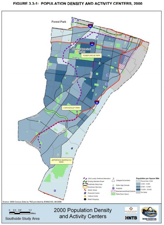
This is a "Cadillac Plan" map that shows full southside transit realization. The De Soto route is in yellow. Oh, to dream!

So what's your preference? Obviously, when we're able to do both lines, we will know this City has truly and finally righted itself, but for a first-effort (which, I'd think, is the most important phase in building support and altering transportation habits), where do you land?

Each route, obviously has its negatives and positives. A Jefferson route, for instance, has a more direct downtown connection, hits the edges of some of the stronger near south neighborhoods and could act as a stabilizing force for n'hoods as you move further south to Broadway/55. De Soto, meanwhile, tags some of the more densely-populated southside areas and represents strong TOD opportunity around former rail-reliant parcels. One exists at the center of east-west bus routes while the other has transfer points nearer those routes eastern termini. Both have the opportunity to stitch neighboring communities together. One would require extensive reconfiguration of surface-level traffic, whereas the other has an existing grade-separated (at most points) ROW, likely reducing the need for demo/construction.

Another option I've considered for the De Soto route is if, rather than following the ROW hump to the edge of SW Gardens/The Hill, if there was a (very expensive) dig down for a subway at Morganford, through TGP, under Tower Grove Avenue and then northward at street level (?) straight through The Grove, CWE and onward -- making it a true N-S line, rather than getting to FPSE and pitching back east toward downtown via the current Red-Blue Metrolink line (or Chouteau). Obviously, cost-prohibitive and entirely different beast than just following an existing ROW though...

5,705
Life MemberLife Member
5,705

PostMay 02, 2014#2

My thoughts come back to two things, a true N-S metrolink line will not happen in the foreseeable future and the best option for the immediate future is full blown support of streetcar expansion within the city itself. Which gets me to the choices on route.

1) Would love to see Jefferson part of a street car network, can tie in with Chouteau Ave on an north south expansion of the Central Corridor line as well as serve as a corridor for expanded street car network for McKee's northside plan.

2) The De Soto Line can be banked for a future heavier metrolink - light rail that should have less stations and better running time to connect South County/Franklin with urban core.

933
Super MemberSuper Member
933

PostMay 02, 2014#3

The Jefferson MetroLink line will be street-running. It's basically a big streetcar. I say let's just make it a streetcar and then do a different N-S line later. We'll get a Jefferson streetcar before a Jefferson MetroLink line.

512
Senior MemberSenior Member
512

PostMay 02, 2014#4

Thanks, guys.

To your second point, dredger, we can all agree that southside access in the City-proper is the most vital starting piece. I don't think the will or interest exists just yet in South County. A southside line terminating at Loughborough Commons represents a pretty substantial park-n-ride (much like the Shrewsbury terminus) for South Countians to dip their toes into the idea of transit. After that, maybe South County would consider something akin to Chicago's Skokie Yellow line...one that transfers at the end of the City line rather than being a continuation of it.

Wouldn't scoff at the idea of heavy-commuter rail along the De Soto, but not at the expense of regular stops at most of those locations designated in the map. I would however love to see heavy rail coming across the Merchants or McKinley, connecting Granite City, Glen Carbon, Edwardsville, etc. (though, to be fair, MCT already has great downtown express buses -- used them everyday back in E'Ville) to a -- hopefully-- reinvigorated northside area and transit system.

GC -- I'm wary of street-running Metrolink too. A strong streetcar system -- or a BRT with stops every mile, say -- seems to be the more logical approach for a Jefferson or a Broadway or a Gravois (the dashed lines on the map).

8,155
Life MemberLife Member
8,155

PostMay 02, 2014#5

nice post at your yastl blog. I think being able to hit The Hill is a bonus and can see some intriguing possibilities with the Reber stop leading to Tower Grove Park. It would be nice to have in the future, and in the meantime I'd like to start our new course to transportation sanity with the Saint Louis Streetcar, but with an additional south leg probably along Jefferson at least to Park if not to Arsenal. As monies become available, keep expanding the N/S legs. I'd also like to see the 70 become real BRT.

1,067
Expert MemberExpert Member
1,067

PostMay 02, 2014#6

Agree with Cadillac description. This line would be a dream come true for south siders and to me would significantly change STL's urban reputation. Light rail is one thing, light rail that incorporates dense residential neighborhoods like this is another. Maybe I'm biased because my old apartment was a few blocks from your MOBOT/The Hill stop.

That said, it seems like not including Soulard, Lafayette Square, Benton Park in south side line is a waste. Ideally, as has been eluded to, this line in combincation with other forms of transit or lines would be optimal.

388
Full MemberFull Member
388

PostMay 02, 2014#7

I personally would like for St.Louis focus on building a world class street car system..I think if Metro link will ever expand we'll need to start seeing a annual population increase as our tax base is becoming a bit too taxed and to get more bang out of your taxes a street car would spur a major boom for all of St.Louis

4,553
Life MemberLife Member
4,553

PostMay 03, 2014#8

This is a great vision, and I applaud (what I consider to be) its realism and pragmatism.

I have a few recommendations for the station locations:
Move the Tower Grove Park station down to Arsenal, it's just as close to the park, but with better bus connectivity.
Move the Patch station seven blocks east to South Broadway (the tracks are already there). S. Broadway connects well to points south (via Telegraph Road), and it is really the "downtown" stretch of Patch, with some nice old historic storefronts. This also would have better bus connectivity.

For a quick n' dirty cost analysis:
The St. Clair County Extension from 5th & Missouri to College was 8 stations, 17.4 miles, and cost just under $500 million in 2014 dollars. De Soto line would be 9 stations (excluding Chippewa and Bates) and 7.9 miles (45% the length of the St. Clair Extension). Both lines run almost entirely on existing freight ROW.

Taking 45% of the St. Clair Extension gives us roughly $225 million. But, considering there is more old infrastructure that would need to be replaced, more expensive land that would need to be acquired, more crossings per mile, and one more station, let's say it costs 2.5X as much (trying to be conservative here). That gives us $563 million. For comparison, Cross County which was 9 stations, 7.4 miles (4.1 miles of which required a completely new ROW with tunneling and other grade separation) cost $744 million in 2014 dollars.

I think its worth it.

933
Super MemberSuper Member
933

PostMay 03, 2014#9

i dunno mayb that $ should go 2 a buncha rural hi-way projects nstead...

414
Full MemberFull Member
414

PostMay 03, 2014#10

Gateway City wrote:i dunno mayb that $ should go 2 a buncha rural hi-way projects nstead...
Highway building has always been paid by user fees, user fees from cars that by state law can only be used on highways. Highway funding distribution in the state is pretty fair by MoDOT districts. MoDOT doesn't just spend funds out of one big pot...each of the 7 districts gets a slice based on formulas that include population, road miles, bridge deck ect.

2,037
Life MemberLife Member
2,037

PostMay 03, 2014#11

I think Gateway City was being intentionally obtuse.

OT:

Being from South City (Lindenwood) I think the De Soto Line would be a lot more attractive to those living on the South side. Being able to visit the Hill and MoBot especially could lead to families taking Metrolink as opposed to wrangling with parking at the Gardens.

414
Full MemberFull Member
414

PostMay 03, 2014#12

Ebsy wrote:I think Gateway City was being intentionally obtuse.

OT:

Being from South City (Lindenwood) I think the De Soto Line would be a lot more attractive to those living on the South side. Being able to visit the Hill and MoBot especially could lead to families taking Metrolink as opposed to wrangling with parking at the Gardens.
What is the density difference between the 2 routes, also has anyone looked at density of places in other cities that are building LRT and their ridership projections vs NS.

8,155
Life MemberLife Member
8,155

PostMay 03, 2014#13

wabash wrote:This is a great vision, and I applaud (what I consider to be) its realism and pragmatism.
Wabash, your thoughtful response reminded me that I believe you posted somewhere a photo of a Vandeventer and Tower Grove rail station.... could you post that again? and do you know precisely where it was?

1,099
Expert MemberExpert Member
1,099

PostMay 03, 2014#14

Knowitall wrote:What is the density difference between the 2 routes

4,553
Life MemberLife Member
4,553

PostMay 03, 2014#15

Hard to believe, but there were actually two separate full-service Tower Grove stations back in the day. This is the station for the Missouri Pacific Railroad:


Here's the station for the St. Louis-San Francisco Railroad or "Frisco," which was down in the viaduct and had stairs leading down to it from Tower Grove Ave.:


It's hard to see on this map, but there's a small grey building with stairs leading down to it just east of the intersection of Tower Grove Ave. & Vandeventer that says "Frisco Station" in it. Northeast of there, at the eastern end of Race Course Ave. is a small white box that says "Mo. Pac Station" in it:

2,037
Life MemberLife Member
2,037

PostMay 03, 2014#16

Does the Chouteau-Jefferson route have a more likely chance of being contructed in the next decade than all the other Metrolink projects that have been banished to Wikipedia?

414
Full MemberFull Member
414

PostMay 03, 2014#17

That depends on what you want to get out of the new line

You want to move people from cars to transit and "choice ridership" you built the Boone expansion

You want people to move from busses to lrt you build NS.

267
Full MemberFull Member
267

PostMay 04, 2014#18

Knowitall wrote:That depends on what you want to get out of the new line

You want to move people from cars to transit and "choice ridership" you built the Boone expansion

You want people to move from busses to lrt you build NS.

I'm not a transportation planner and to tell you the truth I've never taken the time to go over the studies they've done about the different expansion proposals, but I'm not sure if that's necessarily true.

I'm willing to bet there are tens of thousands of people in south and north city that currently drive to work in the central corridor who would take light rail if service was frequent and travel time was similar to rush hour travel time so they could avoid the hassles of traffic congestion and paying for parking. The walkability of the city would allow for nearby residents with cars to feel like walking or biking a few minutes from their doorstep to an LRT stop would be an easy enough alternative.

On the other hand, it seems the Daniel Boone line would primarily serve to get people to and from Westport where a good number of jobs are located, but it isn't very walkable for the most part. The stops along this line would likely be almost entirely park and rides. It's just my opinion that people in St. Louis are less likely to get in their car and drive to a station so they can get on a train (unless they are going to a sporting event downtown) than they are to just simply stay in their car. I personally think Daniel Boone would be less likely to pull in new transit riders than a N-S line simply because of the difference in accessibility the two lines would have.

8,155
Life MemberLife Member
8,155

PostMay 04, 2014#19

^ I agree N/S rapid transit would definitely grow ridership numbers..... a lot more riders would use the 70 route as well if it had its own dedicated r-o-w. If you look at the route of the Cleveland Health Line's (very similar in nature to Saint Louis Streetcar proposed route) ridership numbers jumped substantially after it became street running rapid transit with dedicated lane.

512
Senior MemberSenior Member
512

PostMay 05, 2014#20

What do you mean by choice ridership, KnowItAll? The middle-to-upper class white population? Personally, I think that, yes, activating that "choice ridership" is vital to a better St. Louis. As long as one portion of the population incorrectly assumes public transit is primarily for the poor, Metro can't function fully as a transit system OR an economic driver.

With that said, I think you capture that ridership demo more effectively with a De Soto line. The density is there and I firmly believe the support is there. Families would make heavy use of a Southside Metrolink line. As would adults getting to work in downtown, midtown or Clayton. And I have no doubt that the line's existence would encourage more families to lay down roots, fast-track rehabs, and add new business/multi-use development.

Like blzhrpmd2 said, "Light rail is one thing, light rail that incorporates dense residential neighborhoods like this is another." Our current Metrolink system is heavily-reliant on attractions or places, with very limited access to where people actually live. If a Metrolink line existed near your home (or a quick bus ride away), people would utilize it -- for work, recreation and utility. Yes, even those with cars.

414
Full MemberFull Member
414

PostMay 05, 2014#21

The "choice riders" are people who can drive and can afford cars, but choose to take transit instead

512
Senior MemberSenior Member
512

PostMay 05, 2014#22

Knowitall wrote:The "choice riders" are people who can drive and can afford cars, but choose to take transit instead
Thanks. Still don't think a Boone extension really does that though. Maybe a middle ground of park-n-ride culture would exist, but not as a true transit-supportive system or economic driver.

Looking through the E-W Gateway Southside Metrolink study, there are a lot of interesting maps and diagrams (population density, income, age trends, auto dependence, etc.). Of course, this uses 2000 census data so there would be some change in the data over the past 10+ years.


I can kind of see why they ultimately selected the Jefferson route as the locally-preferred alternative, based heavily on density data between it and Grand. The thing that continues to stand out to me though is how little of the southside that route actually serves. The De Soto line, while touching slightly less dense areas, is centered in the Southside and can therefore better serve neighborhoods both eastward and westward.

1,190
Expert MemberExpert Member
1,190

PostMay 06, 2014#23

There's also the fact that a Jefferson line goes through some of South City's poorest neighborhoods which will go a long way in attracting federal dollars. It's the same reason why the proposed streetcar down Lindell has that North City offshoot. I think that probably paid a big factor in why they chose Jefferson over the Desoto line.

8,155
Life MemberLife Member
8,155

PostMay 06, 2014#24

^ I'm hoping that northern spur of Saint Louis Streetcar unlocks a lot of funding for the project... we'll see if Northside Regeneration has any pull at the federal level or if its all talk.

Back to the Desoto line, another drawback is that it will be harder to spur corridor wide investment... we've seen that difficulty already with our current light rail routes and running street level should have better results.