3,433
Life MemberLife Member
3,433

PostMar 13, 2018#26

I am thrilled to read this news release from MODOT. I attended a MODOT public presentation in October about the new I-44 bridge and talked to the project manager and top engineers on the bridge, pushing for a bike lane to finally link the two long trails on opposite sides of the River. I also exchanged messages with GRG, and Trailnet urging them to push MoDOT to add a bike lane as they did for new bridges over the Missouri River. MoDOT said they would be willing to listen to GRG and Trailnet on this. I offered to rent a room in Kirkwood Community Center to get all parties together, but MoDOT said they would facilitate the meeting.

Then I never heard back, and I assumed the whole idea was dead. So this is surprising and welcome news. I assume there were others bikers and hikers who recognized this rare opportunity to start linking existing trails for recreation, commuting, etc. to get St Louis to become a bike-commuting community. This can allow bikers to bike from the West end of Grant's trail through quiet bike friendly streets of Kirkwood to the Fenton trail that goes all to George Winter Park to the East, and I-141 in Valley Park to the West.

If they finish this by 2022 as planned, I will probably be able to take advantage of this trail link to bike from my home in Kirkwood to George Winter Park on quiet streets and off-road trails. Great job MoDOT, GRG, Fenton, Kirkwood, and Sunset Hills!

http://www.modot.org/stlouis/news_and_i ... sId=214663

-Gary Kreie


Prepared by Andrew Gates, 314/453-1808

March 13, 2018 12:10 PM
MoDOT partners with Great Rivers Greenway, municipalities for I-44 shared use path over Meramec
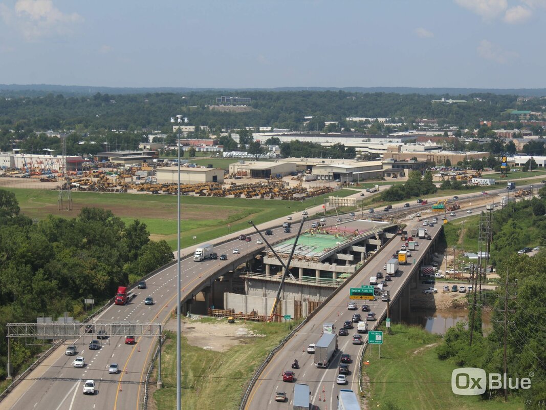
ST. LOUIS – People who use the Meramec Greenway (the shared use path for walking, running or biking) in Fenton and Sunset Hills will be able to cross the Meramec River into Kirkwood when a new shared use path over the river opens in 2022.

The Missouri Department of Transportation and Great Rivers Greenway today came to an initial funding agreement for a shared use path across the Meramec, next to the new I-44 Meramec River bridges. Construction on that project will start this fall, with the construction on the shared use path across the river expected to be complete late in the project.

MoDOT is funding the foundation for the bridge for the shared use path, while Great Rivers Greenway is funding the 12-foot-wide bridge structure across the river. Fenton, Kirkwood and Sunset Hills have tentatively agreed to seek funding for the work to connect the shared use path to the existing Meramec Greenway system on the west side of the Meramec. This connection will also link to Emmenegger Nature Park, Powder Valley Nature Center and Conservation Area, Possum Woods Conservation Area and nearby Laumeier Sculpture Park.

“Over the years, there has been a great deal of interest from the cycling community for a bridge that crosses the Meramec River. We are ecstatic that we are able to partner with Great Rivers Greenway, and the municipalities on both sides of the Meramec River to make this a reality,” said Tom Blair, MoDOT District Engineer for the St. Louis region.

“Bridging over a river is a rare opportunity in any region; creating access that connects communities changes how people get around the region,” said Susan Trautman, CEO of Great Rivers Greenway. “This collaboration of partners demonstrates what can be done when people work together to improve our quality of life – greenways create connections for people to get where they need to go, explore their communities and enjoy some fresh air.”

###

Links to related information:
Meramec River Bridge project

9,565
Life MemberLife Member
9,565

PostMar 14, 2018#27

it helps that the new MoDOT STL District head, Tom Blair is an avid cyclist and the head of planning for the modot stl district, who does across state bicycle rides like the one people do across Iowa in a week

3,433
Life MemberLife Member
3,433

PostApr 20, 2018#28

Nice front-page piece on the front of the Webster - Kirkwood Times newspaper about the planned pedestrian/bicycle bridge across the Meramec River linked to the new I-44 car bridge over the river at I-270.


Here is the Front Page Article:
http://www.timesnewspapers.com/Articles ... -Deal.html

And here is a related piece in the same issue about $979,000 grant for associated trails near I-44 and the Meramec River.
http://www.timesnewspapers.com/Articles ... -Path.html

PostAug 09, 2019#29

MODOT is having an open house seeking early planning comments about the new pedestrian/bicycle bridge planned to cross the Meramec River parallel to the new I-44 Meramec River bridge being constructed at I-44 at I-270.  

Date: August 20, 6-8 PM, Sunset Hills Community Center, 3915 S. Lindbergh Blvd, Sunset Hills, MO. 63127.


This bridge will be the key element that should finally allow a link between the long walking and bicycling trails along the Meramec River. There is a long trail from Valley Park to Kirkwood North and West along the river, and a long trail from Unger Park to George Winter Park on the South and East along the river.  But no way to connect them into one long trail linking the Meramec Greenway.  But MODOT, GRG, Sunset Hills, Fenton, and Kirkwood came together to plan for a new ped/bike bridge over the Meramec with a short connector trail to link up the Greenway.  And it will provide a path to Powder Valley and the rest of Kirkwood via Geyer Road.

Here is what MODOT put on their site at this link (at the very bottom of their page):

  https://www.modot.org/i-44-meramec-river-bridge-replacement

Residents of the region, especially in the communities of Kirkwood, Fenton and Sunset Hills, are invited to an open house about the project to build a connection for people walking and biking on the new Interstate 44 bridge over the Meramec River. The municipalities of Fenton, Kirkwood and Sunset Hills in South St. Louis along with project partners Great Rivers Greenway and the Missouri Department of Transportation (MoDOT) invite neighbors to learn about the project and give their input during this early planning phase (will bid for construction at the end of 2020). People can stop by anytime for light refreshments and to check out display boards, talk to staff and fill out a survey. 
The open house is on Tuesday, August 20th, between 6-8 p.m. at the Sunset Hills Community Center, 3915 S. Lindbergh Blvd., Sunset Hills, MO 63127. All display materials and feedback questions will be available online after the meeting until September 5th for anyone unable to attend the event
At this time concepts are being explored to guide the design of trail connections and amenities associated with the bridge. Public input and technical feasibility are important components of the concept development. This project has several goals:
  • Provide people with a safe and accessible way to cross the Meramec River while walking, running or riding a bike.
  • Connect to the Meramec Greenway, parks, trails, businesses, neighborhoods and other destinations on either side, including possible new trailheads with amenities like a restroom, benches and parking. 
  • Allow people to connect to the Meramec River itself; inviting people to enjoy nature leads to ownership and opportunities to be good stewards of these natural resources for the health and long-term sustainability of our watershed and communities. 
During early public informational open house on the Meramec River Bridge project, MoDOT received a great deal of feedback from the community on their thoughts about a connection between the east and west sides of the Meramec for cyclists and pedestrians.  The majority of that feedback was in support of some form of a cyclist/pedestrian crossing near I-44.  Since that time, MoDOT has partnered with Great Rivers Greenway and the surrounding municipalities to come to an agreement about constructing a shared-use path across the river.  On March 13, 2018, the department came to a formal agreement with Great Rivers Greenway about a partnership to construct a 12-foot protected path for walking and biking on the bridge, and it continues to work with local municipalities about funding to connect that bridge path to existing trails on either side of the bridge. As the project continues toward the start of construction, we will continue to provide updates on the details of this solution.

985
Super MemberSuper Member
985

PostAug 11, 2019#30

Interested to see what sort of connections can branch out from the bridge. Hopefully piecing together the segments of existing trails and parks could create a nice network in this portion of St. Louis County. Would there be alignments set up with defined routes that can connect the Meremec River trails to downtown Kirkwood to Grant's Trail creating a full link from St. Louis City to the Meremec River.

Is there a mechanism for Jefferson and Franklin Counties could join the Great Rivers Greenway district? Since the Meremec River routes would be the ideal ways to provide links to those counties, and I think entities in both counties have proposed connecting segments to enter their jurisdictions. If that happened it could allow connectins to more towns,  other trails, state parks, and conservation areas.

3,433
Life MemberLife Member
3,433

PostAug 11, 2019#31

Right.  St. Louis really is an ideal metro for bicycle commuting, in that it has lots of flat off-road trail options.  Tops of levies, along rivers/streams under car bridges, abandoned railroad track right-of-way, flat flood plains, and across the river, flat Illinois farmland where every farm road appears to be paved.  So if we could link up trails on these sites, we could form a mostly off-road bicycling network allowing actual bicycle commuting.  Someday.

With respect to the Meramec bridge, once it is built it would only take a short connector from the North End of Cragwold Road down to Marshall Road through the trees along I-270 to connect the two long ends of the Meramec Greenway trails. 

PostAug 21, 2019#32

I attended the MODOT Open House about the planned pedestrian / bike bridge over the Meramec River at I-44 / I-270 that will parallel the new I-44 bridge being built.  The placards basically showed how the bridge will link up with existing trails at Emmenegger Nature Park on the East side of the river and with Fenton trails and Unger Park trails on the West side of the river. The pictures imply the bridge will be as high and as long as the car bridge, so walkers and bikers will back track up and down the sides of the riverbank, certainly for easy (ADA?) slope entrance.  Looks like there may be shortcut steep access to the ends of the bridge too.   Contracts are expected to be let next year.

I talked to a Kirkwood City person about linking the trail from Valley Park on the North side of the river to this bridge, say, via little used Cragwold Road.  It would require about a 1/3 mile connector near I-270 and Marshall Road.  He said there have been problems with homeowners in that area in the past that he thinks would kill any connection.  I asked -- what about just going down the I-270 right-of-way to Marshal Road -- as was apparently intended given the way Cragwold Road ends.  He thought that might be a possibility.

There seemed to be a lot of people there who don't appear to exercise at all.  Not sure if it was an organized effort, but most of those folks thought it would raise their taxes, so wanted it killed.  I believe MODOT was telling them the budgets were already approved at state and federal levels. Not sure if towns are kicking in $$s or not.

1
New MemberNew Member
1

PostAug 22, 2019#33

gary kreie wrote: I attended the MODOT Open House about the planned pedestrian / bike bridge over the Meramec River at I-44 / I-270 that will parallel the new I-44 bridge being built.  The placards basically showed how the bridge will link up with existing trails at Emmenegger Nature Park on the East side of the river and with Fenton trails and Unger Park trails on the West side of the river. The pictures imply the bridge will be as high and as long as the car bridge, so walkers and bikers will back track up and down the sides of the riverbank, certainly for easy (ADA?) slope entrance.  Looks like there may be shortcut steep access to the ends of the bridge too.   Contracts are expected to be let next year.

I talked to a Kirkwood City person about linking the trail from Valley Park on the North side of the river to this bridge, say, via little used Cragwold Road.  It would require about a 1/3 mile connector near I-270 and Marshall Road.  He said there have been problems with homeowners in that area in the past that he thinks would kill any connection.  I asked -- what about just going down the I-270 right-of-way to Marshal Road -- as was apparently intended given the way Cragwold Road ends.  He thought that might be a possibility.

There seemed to be a lot of people there who don't appear to exercise at all.  Not sure if it was an organized effort, but most of those folks thought it would raise their taxes, so wanted it killed.  I believe MODOT was telling them the budgets were already approved at state and federal levels. Not sure if towns are kicking in $$s or not.
This has always seemed the workable solution to me.  I don’t think there are currently safe access walk/bike tie ins to Kirkwood proper thru Geyer, Craigwold and Stonybrook, certainly not of easy grade and access. Anything constructed near the oppressive noise and smells of the highway would seem less than ideal.  Using the existing abandoned westbound I-44 wins on adaptive reuse, but leaves massive grade barriers to remedy on each side of the river. At one time, I believe Kirkwood had a workable plan to join their main grid bike trails with Greentree Park via Marshall Road, a subdivision, or the Treecourt Apartments.  If so, with a bit more roadbed and an additional bridge strategically placed in downtown Kirkwood, (Eagle Scout project?) all of these trails could be connected with the Grants Trail for a truly cross-county network of considerable length.  Please share for comments.  philwilson@earthlink.net 
F7A68B0B-B446-4A3A-BE96-54C0A7252847.jpeg (1.18MiB)

3,433
Life MemberLife Member
3,433

PostAug 22, 2019#34

I used to advocate for a new pedestrian / bike bridge across the Meramec River near Greentree over to Unger, or further up at Buder Park, but unless there is a large private donation for that, nobody has the money for that bridge.  I also bugged GRG a few years ago for a ped bridge resting on the unused half of the railroad piers near the 141 car bridge  in Valley Park, where 2 tracks used to cross the river, not now it's just one.  But GRG wasn't interested, saying they are going to assume the BNR railroad wouldn't allow it.   (It now looks very shortsighted for designers not to have included a ped/bike component to the 141 car bridge in Valley Park.). 

So the new I-44 bridge provides the only opportunity -- probably in my lifetime -- for money via Missouri, US, government budgets for a ped / bike connection across the river.

With regard to the connector to Grant's Trail from downtown Kirkwood via a bridge over East Monroe, at the I-44 meeting, I also brought that up to a Kirkwood person at the I-44 meeting.  Depending on what Kirkwood Trail Plan you look at, there have been plans for 1) a trail all the way along the old abandoned Kirkwood rail extension (used for the rest of Grant's Trail) from Holmes to Monroe and Fillmore, or 2) A shortened versions of 1 that only goes from Holmes to the rail crossing at west end of Leffingwell and Scott, or 3) A shorter version that goes from Holmes but jumps over to Elliot Street and follows Elliot and Lillian on-street to reach Fillmore.  Here are pics from the 2005 plan and the current 2015 plan.


PostAug 22, 2019#35

By the way, I see from this link
 https://www.acppubs.com/articles/8373-missouri-dot-makes-progress-on-three-year-effort-to-replace-i-44-meramec-river-bridges 
these details about the planned pedestrian / bike bridge over the Meramec River:

""The 12-foot-wide pedestrian pathway will share the same substructure as the new westbound I-44 bridge, but will be located on a separate superstructure. This design will help to protect those accessing areas such as the existing Meramec Greenway, Emmenegger Nature Park, Powder Valley Conservation Nature Center, and Possum Woods Conservation Area.

Grana adds, “There will be a 10-foot gap between the two superstructures to accommodate future inspections of the structures as well as provide a buffer between the interstate traffic and bicyclists and pedestrians. MoDOT is continuing to work with Great Rivers Greenway and other municipalities in developing plans for the connections from the multi-use bridge to adjacent trails and local streets.”"

And this photo shows the supports for the bike bridge on the far right side of the piers for the westbound north bridge lanes. 


PostAug 22, 2019#36

There is a survey button at the very bottom of the MODOT I-44 Bridge page at this link concerning the pedestrian / bike bridge.  When you take the survey, it shows a lot pictures from the open house of options and plans for how they intend to connect the bike / ped bridge to the existing trails.

https://www.modot.org/i-44-meramec-river-bridge-replacement

PostOct 27, 2019#37

New survey results from second MODOT / GRG meeting on pedestrian / bike bridge over the Meramec River at I-44 / I-270.
Scroll to Bottom of the Page:  https://www.modot.org/i-44-meramec-river-bridge-replacement


985
Super MemberSuper Member
985

PostOct 28, 2019#38

These drawings really bring up the question why some sort of pedestrian/bike lane was not put in when they worked on the 141 bridge? Though if i recall they only did minor modifications to the bridge in the late 1990s to add lanes, so it may have been for that reason. Also there wasn't any trail on the north side yet.

Are there any other possible Meremec River crossings?

4
New MemberNew Member
4

PostDec 20, 2019#39

A Webster Kirkwood Times published letter from a long time Kirkwood Park Board member.
Driver’s Ed At High School, License Bicyclists
  • Alan Hopefl
  •  
  • Dec 13, 2019
  •  
It was encouraging to see that public education is going to be a major part of Kirkwood’s Complete Streets program for the promotion of traffic and pedestrian safety (Webster-Kirkwood Times, Dec. 6 issue). This is where we need to begin, but results will be slow and there will be resistance.
The city council needs to cajole the Kirkwood School Board to mandate driver’s education at the high school as a graduation requirement. This will teach not only motor vehicle safety, but also cyclist and pedestrian safety skills. The school district does have a wellness committee.

City council should begin working with St Louis County to require licensing of cyclists. If they are going to use the roads they need to demonstrate competence of traffic laws and cycling safety. There should be a required three hour course on cycling safety and applicable traffic laws, passage of a short test and payment of a small fee to obtain a county bicycle license. St Louis County has an Action Plan for Walking and Biking that could help with this.
Of course, attainment of measurable objectives of the safety program must be conveyed to the public in a timely manner. Unfortunately, what we will likely see in Kirkwood is more paint on our roads and flashing electronic signs that drivers and pedestrians ignore and that accomplish nothing of actual benefit.

PostDec 20, 2019#40


sc4mayor
sc4mayor

PostJun 16, 2021#41

There is something I like about watching new, large infrastructure projects come together...
The new 44 bridges over the Meramec are looking good...also looks like they're working on building out the pedestrian/cycle path that will anchor the northern edge of the new structure.


https://app.oxblue.com/open/modot?camer ... ac64e3dab0

3,433
Life MemberLife Member
3,433

PostJun 21, 2021#42

Are we sure that is the trail bridge in the construction photo?  Or is it a dedicated car bridge for Soccer Park and the new mega-truck stop? Maybe it is the trail bridge, and they'll finish it well ahead of the connections to it, but I'm skeptical.  Seems hard to find info on this from Modot, GRG, Trailnet, etc.  Maybe the Post can ask modot for an update.  Is the money even allocated?

According to GRG website, "Preliminary plans were presented to each of the municipal boards and approved in 2020. The trail connections are progressing through final design. MoDOT will bid the shared use path for construction in 2021 with construction expected to be complete by early 2022."

https://greatriversgreenway.org/walking-and-biking-connection-to-i-44-bridge/

sc4mayor
sc4mayor

PostJun 21, 2021#43

^ I'm pretty sure.  The Soccer Park and entrance ramps from 270 will be on the right hand side of the already in place jersey barrier, opposite the 44W thru lanes.  Which would leave the narrower bridge on the outside for the ped connection.

GRG lists it as a "Project in Progress" here:
https://greatriversgreenway.org/meramec ... ster-plan/

But you're definitely right, it's not exactly easy to find information about it...

sc4mayor
sc4mayor

PostJun 21, 2021#44

I took another look and I'm still pretty sure that's it.  Here is the schematic of the new crossing from MoDot:


And another look at the webcam with some notes.  Plus if you look at the landing for the ped path it's awfully narrow looking for cars and trucks:

3,433
Life MemberLife Member
3,433

PostJun 21, 2021#45

I think you're right!  I guess I had seen the first picture someplace a while back and assumed the supports under construction now were the 2 lanes going to soccer park.  But from your pictures, it is clear the most northern bridge supports under construction now are not even on the first picture.  So they must be the shared pedestrian-bike path.  

It looks as if the East bound lanes are fully finished and striped in their final form  with a dotted line shunting two lanes to I-270 and Watson.  But the West bound car lanes now in use appear to be striped temporarily with 3 main lanes going West, but with the fast lane essentially on the future shoulder temporarily.  And then a dotted line creates a 4th lane on the right for Soccer park/service road traffic for a while the final soccer park (2-lanes) are under construction and on the north side of the barrier.  So that means the final North bridge supports must be for the ped/bike path!

So happy to see this in my lifetime.  Hope someone is thinking of a good safe way to get from Grant's Trail in Kirkwood to the new bridge, and from the East end of the Meramec trail to the new bridge eventually.  But just being able get to all the trails on the other side of the river from the parks on this side of the river is a huge first step.

sc4mayor
sc4mayor

PostJun 22, 2021#46

gary kreie wrote:
Jun 21, 2021
It looks as if the East bound lanes are fully finished and striped in their final form  with a dotted line shunting two lanes to I-270 and Watson.  But the West bound car lanes now in use appear to be striped temporarily with 3 main lanes going West, but with the fast lane essentially on the future shoulder temporarily.  And then a dotted line creates a 4th lane on the right for Soccer park/service road traffic for a while the final soccer park (2-lanes) are under construction and on the north side of the barrier.  So that means the final North bridge supports must be for the ped/bike path!
This is pretty much exactly as I understand it.  Good stuff!

9,565
Life MemberLife Member
9,565

PostJun 22, 2021#47

When planned this job and set up the financing I put in money specifically for the bike/ped. Kinda cool to see some of these things come to life, it’s usually a 5-7 year process.

3,433
Life MemberLife Member
3,433

PostJun 23, 2021#48

dbInSouthCity wrote:When planned this job and set up the financing I put in money specifically for the bike/ped. Kinda cool to see some of these things come to life, it’s usually a 5-7 year process.
Thanks D. It might be a few years but I’m convinced in a while we’ll see the value in this investment.


Sent from my iPhone using Tapatalk

7,810
Life MemberLife Member
7,810

PostJun 23, 2021#49

I assume this is an effort to connect the Meramec Greenway and Gravois Greenway?

https://greatriversgreenway.org/greenway-search/

sc4mayor
sc4mayor

PostJul 13, 2021#50

gary kreie wrote:
Jun 23, 2021
dbInSouthCity wrote:When planned this job and set up the financing I put in money specifically for the bike/ped.   Kinda cool to see some of these things come to life, it’s usually a 5-7 year process.
Thanks D. It might be a few years but I’m convinced in a while we’ll see the value in this investment.


Sent from my iPhone using Tapatalk
Gary, thought you might find this interesting.  Sounds like the connections on either side are currently in final design.  Still not a ton of info, but more than I’ve been able to find elsewhere.
https://greatriversgreenway.org/walking ... 44-bridge/

Read more posts (21 remaining)