Is that UW facade terra cotta? I have seen a few people on this forum refer to it as a new building material, but don't see many examples of it. The original terra cotta was a nightmare to work with on restorations...Elek.borrelli wrote: ↑Jun 09, 2020I appreciate the feedback and agree with your point. The program I'm using only allows for the bare minimum amount of detail, so this is what I was thinking: The gray part of the façade would be clad with terracotta, just like the picture you see below. I was initially thinking of a light gray coloring, but I am a big fan of this lighter brown brick color; it would tie into the surrounding buildings nicely. For the windows, I was thinking of the example below: there would be two in each rectangular cutout with a black divider (not sure what the term for those is). The curved portion of the glass would match the other windows.framer wrote: ↑Jun 09, 2020The rendering looks a little "empty" to me. Honestly, it looks more like a garage than a residential building. Maybe figure out how to liven up the windows.
Terra cotta seems to be making a comeback; it's very hot in New York right now. My favorite (new construction) is The Fitzroy. Lots of good pics here:
https://newyorkyimby.com/2019/08/the-fi ... elsea.html
![]()
https://newyorkyimby.com/2019/08/the-fi ... elsea.html
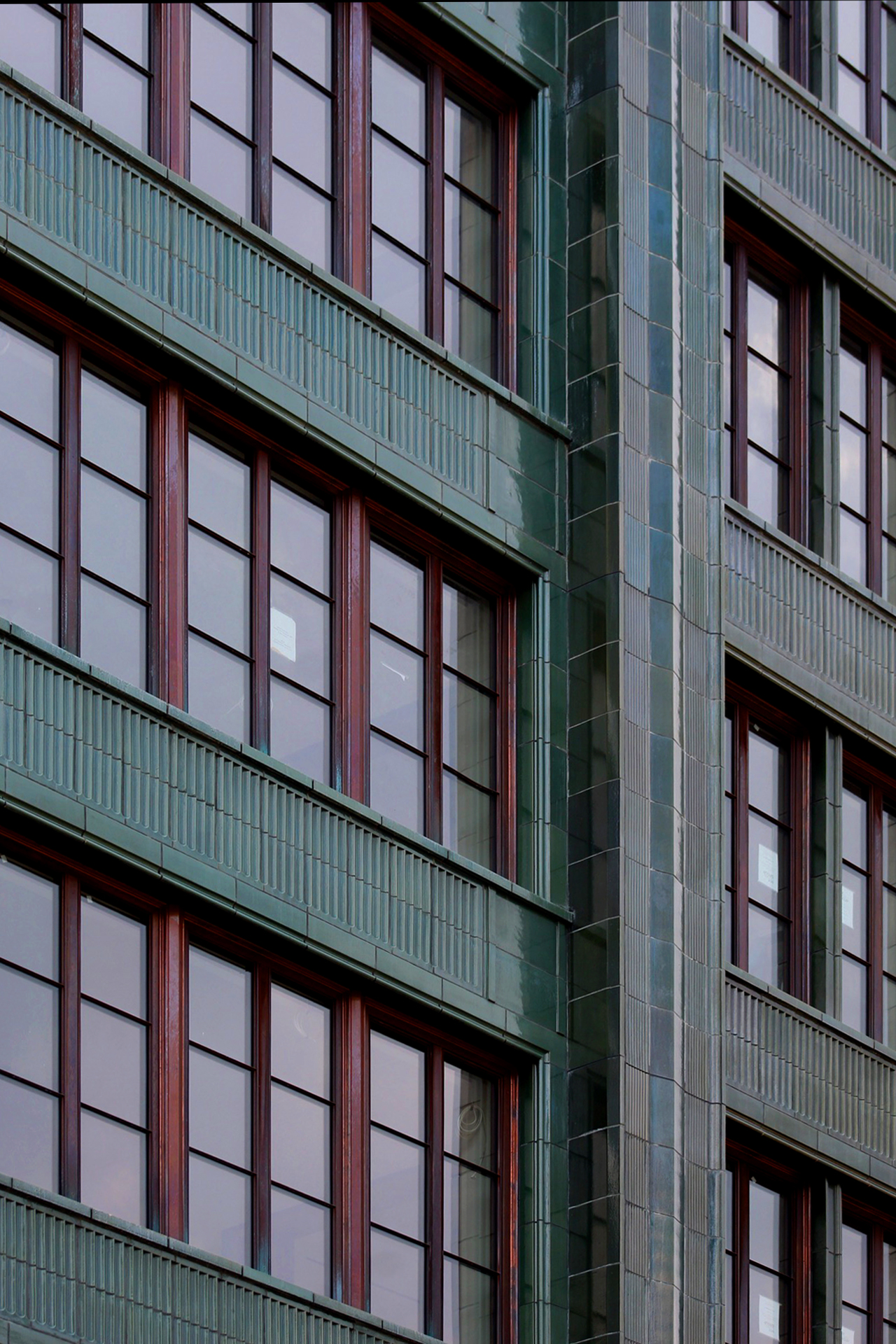
And here's a company doing lots of terra cotta in NY, with pics and links to several projects:
https://bostonvalley.com/facades-in-nyc/
https://bostonvalley.com/facades-in-nyc/
- 340
^ Thanks, Framer! 111 west 57th Street is another excellent example of its use in modern construction. It's a great looking building, in my opinion. I'm pretty sure the B1M made a video about its use on this building in particular.

Hi all! As we all know, St. Louis has a lot of riverfront real estate. Due to the Mississippi's unforgiving flooding as well as urban renewal, St. Louis has seen almost all connections to this colossal water-way severed. European cities founded along rivers have developed great spaces for pedestrians and bikers that overlook the water, and, having visited these cities and seen the urban paradise that is these riverfront parks, I thought I'd try to bring a similar concept to the North Riverfront.


This project would call for the construction of an elevated pedestrian area that would act as both a flood wall and a park. Rising 20 feet out of the Mississippi, the park would be among the most visited places in the region. Home to basketball courts, tennis/ pickleball courts, indoor racketball courts, a food hall, walking/ biking areas, as well as a 2-acre white sand beach all while being open to the public, this would be a paradise. It would be built along with the Founders District Masterplan and would add much needed desire for apartments and office space all while fueling rehabs along N. Broadway.


- 805
Love it! Would probably need to make the “beach” a bit bigger, but the riverfront really needs a public space draw like this.Elek.borrelli wrote:Hi all! As we all know, St. Louis has a lot of riverfront real estate. Due to the Mississippi's unforgiving flooding as well as urban renewal, St. Louis has seen almost all connections to this colossal water-way severed. European cities founded along rivers have developed great spaces for pedestrians and bikers that overlook the water, and, having visited these cities and seen the urban paradise that is these riverfront parks, I thought I'd try to bring a similar concept to the North Riverfront.
Sent from my iPhone using Tapatalk
- 340
The beach is modeled off of Brisbane's "Streets Beach". It would be nearly identical in size: 735' long and 120' wide (Streets Beach walkthrough).
Looks great, though I'm not sure it would need to be elevated. Just use plantings, benches, and other features that can be more easily submerged like they did along the newer part of LKS for flooding.
- 805
Ah, that’s plenty big then! Looks great. Pitch it to downtown Stl.Elek.borrelli wrote:The beach is modeled off of Brisbane's "Streets Beach". It would be nearly identical in size: 735' long and 120' wide (Streets Beach walkthrough).
Sent from my iPhone using Tapatalk
- 340
I would want it to be generally flat so it's more accommodating to the disabled/ elderly. Also, I'm not sure if this area is in Downtown STL's jurisdiction. Maybe I pitch it to the guys at New Legacy Development. Without something major like this, their plan of 500,000+ square feet of office and 1,200+ apartments would come to nothing.
- 337
I don't believe elevated would be a needed portion of the design. I think you can still create a wonderful walkable riverfront on grade and keep all people at the same level which in turn makes it feel safer. Also, you may want to dive into the theory and purpose of a lot of riverfronts as some of the most beautiful typically aren't described as floodwalls but in fact are described as flood mitigating which are two different things. Floodwalls just push the problem downstream because the water isn't able to naturally fill the space as it historically did whereas flood mitigation allows water to inhabit some spaces of the design and maybe even hold the water so it doesn't affect something downstream even more. May want to dive into waterfront/riverfront projects by firms such as OJB and SWA.
- 2,663
Chouteau Lake would have been a good opportunity to do something like this. Could be similar to the Colorado River running next to downtown Austin. People use that water. Also still a fan of damming up the River Des Peres assuming we can solve its sewage issues.
Not too keen on the elevated space idea. That's just gonna cut people off from the river even more than we are now. As others have said, you need to figure out how to interact WITH the river, not build barriers against it.
- 340
Are you suggesting something like the Pier 4 in Boston? My only problem is that flooding would make this park unusable for a large portion of the year if it were up that close to the water. My understanding is that no one uses the river; it's too violent and dirty. A river 15' - 20' below a pedestrian area doesn't necessarily cut connection, in my opinion. Rivers like the Thames in London or the Spree in Berlin are around that elevation in most areas. The city already has flood walls established along that section of the river as well, and I don't think they'd be too keen to have them removed.


- 337
Sometimes a parks purpose is to be flooded to save something downstream. Buffalo bayou in Houston for example.
- 340
^ I'll look into it! Thank you all for the helpful suggestions as this is my first urban planning concept so to speak.
I used some of the feedback I got and tweaked the plan a bit. Take a look:


^I've always thought it would be cool to extend the staircase in front of the Arch all the way down to the low river level, while breaking up the concrete monotony with planters / landscaping.
That is more or less what you've done in the third rendering, just further north. I do think the terraced riverfront is the only reasonable approach. What is the light and dark, erm speckled, area? Levee stones?
That is more or less what you've done in the third rendering, just further north. I do think the terraced riverfront is the only reasonable approach. What is the light and dark, erm speckled, area? Levee stones?
- 340
They are concrete supports that raise the area above. Portions of it are elevated like a pier, and this allows for water to flow under the park. That was my solution to getting rid of a flood wall!
Also, it looks like columns or piers supporting a boardwalk?
Any supports like that would have to be drilled or driven down into the bedrock below the river or would be undermined very quickly. Trees also get lodged and tangled in between them and the pressure of the river flow on all the debris exponentially increases the force on the piers and foundation.
One of the factors that makes our riverfront so difficult to develop is the depth and speed of the river at flood stage as it passes through downtown. There aren't many comparable riverfronts in the US, or anywhere really.
I meant the area in between the stairs that runs parallel to the river, in three separate strips, light grey with dark spots, on the third rendering...Elek.borrelli wrote: ↑Jul 02, 2020They are concrete supports that raise the area above. Portions of it are elevated like a pier, and this allows for water to flow under the park. That was my solution to getting rid of a flood wall!
- 337
I think the intention of the design is better. I would challenge you to somehow calculate the hardscape vs softscape. It just seems overly hardscaped to me which being next to a river would increase flow speed during flood events. I would break up maybe ever 2-3 stair sections down to the water with more natural grass and vegetation or a natural setting of stone instead of the direct stairs. Possibly think about hor your tree areas become basins to hold water as well and how that may change the vegetation type within them. your photoshop skills are getting better for sure though.
- 340
The light gray area with dark spots is the flooring of the pedestrian area. It is meant to match that of Kiener Plaza.urbanitas wrote: ↑Jul 02, 2020I meant the area in between the stairs that runs parallel to the river, in three separate strips, light grey with dark spots, on the third rendering...